
File:Sy-map.png
冇更高解像度嘅圖像。
Sy-map.png (326 × 350 像素,檔案大細:11 KB ,MIME類型:image/png)

|
This locator map image could be recreated using vector graphics as an SVG file. This has several advantages; see Commons:Media for cleanup for more information. If an SVG form of this image is already available, please upload it. After uploading an SVG, replace this template with {{vector version available|new image name.svg}}.
|
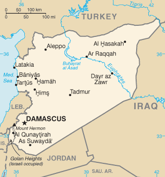
CIA map of Syria
This image is in the public domain because it contains materials that originally came from the United States Central Intelligence Agency's World Factbook.
|
 |
檔案歷史
撳個日期/時間去睇響嗰個時間出現過嘅檔案。
| 日期/時間 | 縮圖 | 尺寸 | 用戶 | 註解 | |
|---|---|---|---|---|---|
| 現時 | 2011年1月14號 (五) 13:04 | | 326 × 350(11 KB) | Ras67 | cropped |
| 2009年1月11號 (日) 07:59 |  | 328 × 353(12 KB) | Timeshifter | Latest version of the map from the CIA Factbook page for Syria. That page was last updated Dec. 18, 2008. I converted the GIF image to PNG using the freeware IrfanView PNGOUT to losslessly compress the image to palette PNG. | |
| 2005年5月12號 (四) 13:35 |  | 328 × 352(12 KB) | Eirik | CIA map of syria {{PD-USGov-CIA-WF}} Category:Maps of Syria |
檔案用途
以下嘅1版用到呢個檔:
全域檔案使用情況
下面嘅維基都用緊呢個檔案:
- ace.wikipedia.org嘅使用情況
- ar.wikipedia.org嘅使用情況
- azb.wikipedia.org嘅使用情況
- be-tarask.wikipedia.org嘅使用情況
- bg.wikipedia.org嘅使用情況
- bg.wiktionary.org嘅使用情況
- br.wikipedia.org嘅使用情況
- ca.wikipedia.org嘅使用情況
- ca.wikinews.org嘅使用情況
- da.wikipedia.org嘅使用情況
- de.wikipedia.org嘅使用情況
- de.wikinews.org嘅使用情況
- diq.wikipedia.org嘅使用情況
- dsb.wikipedia.org嘅使用情況
- el.wikipedia.org嘅使用情況
- el.wikinews.org嘅使用情況
- en.wikipedia.org嘅使用情況
- en.wikinews.org嘅使用情況
- en.wikiquote.org嘅使用情況
- en.wiktionary.org嘅使用情況
- eo.wikipedia.org嘅使用情況
- fi.wikipedia.org嘅使用情況
- fr.wikipedia.org嘅使用情況
- fr.wikinews.org嘅使用情況
- gl.wikipedia.org嘅使用情況
- gu.wikipedia.org嘅使用情況
- hif.wikipedia.org嘅使用情況
- hi.wikipedia.org嘅使用情況
- hi.wiktionary.org嘅使用情況
- id.wikipedia.org嘅使用情況
- incubator.wikimedia.org嘅使用情況
- ja.wikipedia.org嘅使用情況
- jv.wikipedia.org嘅使用情況
- ko.wiktionary.org嘅使用情況
- mai.wikipedia.org嘅使用情況
- mr.wikipedia.org嘅使用情況
睇呢個檔案嘅更多全域使用情況。