
File:TAAF-CIA WFB Map.png

預覽大細:466 × 599 像素。 第啲解像度:187 × 240 像素|373 × 480 像素|690 × 887 像素。
原本檔案 (690 × 887 像素,檔案大細:49 KB ,MIME類型:image/png)
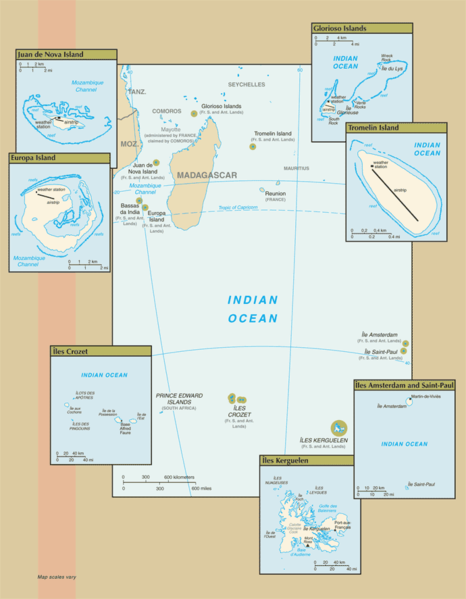
Map of the French Southern and Antarctic Lands, from CIA.gov
This image is in the public domain because it contains materials that originally came from the United States Central Intelligence Agency's World Factbook.
|
 |
檔案歷史
撳個日期/時間去睇響嗰個時間出現過嘅檔案。
| 日期/時間 | 縮圖 | 尺寸 | 用戶 | 註解 | |
|---|---|---|---|---|---|
| 現時 | 2007年7月25號 (三) 10:14 | | 690 × 887(49 KB) | Hoshie | Updated map of the French Southern and Antarctic Lands from the CIA World Factbook, 19 July 07 rev. Src: https://www.cia.gov/library/publications/the-world-factbook/maps/fs-map.gif |
| 2006年1月18號 (三) 09:12 |  | 328 × 352(7 KB) | Hoshie | Map of the French Southern and Antarctic Lands, from [http://www.cia.gov/cia/publications/factbook/maps/fs-map.gif CIA.gov] {{PD-USGov-CIA-WF}} |
檔案用途
以下嘅1版用到呢個檔:
全域檔案使用情況
下面嘅維基都用緊呢個檔案:
- af.wikipedia.org嘅使用情況
- az.wikipedia.org嘅使用情況
- be-tarask.wikipedia.org嘅使用情況
- bn.wikipedia.org嘅使用情況
- ca.wikipedia.org嘅使用情況
- cy.wikipedia.org嘅使用情況
- de.wikipedia.org嘅使用情況
- en.wikipedia.org嘅使用情況
- eo.wikipedia.org嘅使用情況
- es.wikipedia.org嘅使用情況
- frr.wikipedia.org嘅使用情況
- gl.wikipedia.org嘅使用情況
- id.wikipedia.org嘅使用情況
- it.wikipedia.org嘅使用情況
- lv.wikipedia.org嘅使用情況
- mk.wikipedia.org嘅使用情況
- mt.wikipedia.org嘅使用情況
- nds-nl.wikipedia.org嘅使用情況
- nn.wikipedia.org嘅使用情況
- ro.wikipedia.org嘅使用情況
- war.wikipedia.org嘅使用情況
- zh.wikipedia.org嘅使用情況