
File:Temple of Friendship in Pavlovsk Park 01.jpg

原本檔案 (4,200 × 2,800 像素,檔案大細:10.35 MB ,MIME類型:image/jpeg)
| 描述 |
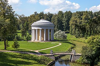
English: Temple of Friendship in Pavlovsk Park
Русский: Храм Дружбы в Павловском парке
|
|||||||||
| 日期 | Taken on 2013年7月29號 | |||||||||
| 來源 | 自己作品 | |||||||||
| 作者 | Florstein (Telegram:WikiPhoto.Space) | |||||||||
| 許可 (重用呢個檔案) |
Alex 'Florstein' Fedorov, the copyright holder of this work, hereby publishes it under the following licenses: This file is licensed under the Creative Commons Attribution-Share Alike 4.0 International license. 姓名標示: Alex 'Florstein' Fedorov
你可以揀你想用嘅牌照。 |
|||||||||
| Overwriting existing files |


| Camera location | | View this and other nearby images on: OpenStreetMap |
|---|
|
This image was selected as picture of the day on Wikimedia Commons for 5 August 2014. It was captioned as follows: English: Temple of Friendship in Pavlovsk Park in Saint Petersburg. Other languages:
Deutsch: Tempel der Freundschaft in Pawlowsk-Park (Sankt Petersburg). English: Temple of Friendship in Pavlovsk Park in Saint Petersburg. Magyar: Barátság temploma a szentpétervári pavlovszki parkban Македонски: Храм на пријателството во Павловскиот парк, Санкт Петербург. 한국어: 상트페테르부르크 파블롭스크 공원의 우정의 신전. 中文: 俄罗斯圣彼得堡巴甫洛夫斯克公园友谊殿。 |

|
This image was uploaded as part of Wiki Loves Monuments 2013.
|
| Object location | | View this and other nearby images on: OpenStreetMap |
|---|
檔案歷史
撳個日期/時間去睇響嗰個時間出現過嘅檔案。
| 日期/時間 | 縮圖 | 尺寸 | 用戶 | 註解 | |
|---|---|---|---|---|---|
| 現時 | 2014年1月27號 (一) 16:44 | | 4,200 × 2,800(10.35 MB) | Florstein | Minor CAs at the left. |
| 2014年1月27號 (一) 16:13 |  | 4,200 × 2,800(10.33 MB) | Florstein | Dust spot (or bird) removed. | |
| 2013年9月22號 (日) 09:38 |  | 4,200 × 2,800(10.31 MB) | Florstein | {{User:Florstein/Inf |Description= {{Cultural Heritage Russia|id = 7810339069}} {{en|Temple of Friendship in Pavlovsk Park}} {{ru|Храм Дружбы в Павловском парке}} |Year=2013 |Month=07 |Day=29}} {{Wiki Loves Monuments 2013|ru}}... |
檔案用途
以下嘅1版用到呢個檔:
全域檔案使用情況
下面嘅維基都用緊呢個檔案:
- ast.wikipedia.org嘅使用情況
- be-tarask.wikipedia.org嘅使用情況
- bn.wikipedia.org嘅使用情況
- ca.wikipedia.org嘅使用情況
- crh.wikipedia.org嘅使用情況
- cv.wikipedia.org嘅使用情況
- de.wikipedia.org嘅使用情況
- en.wikipedia.org嘅使用情況
- en.wikivoyage.org嘅使用情況
- es.wikipedia.org嘅使用情況
- fi.wikipedia.org嘅使用情況
- hsb.wikipedia.org嘅使用情況
- hu.wikipedia.org嘅使用情況
- incubator.wikimedia.org嘅使用情況
- is.wikipedia.org嘅使用情況
- it.wikipedia.org嘅使用情況
- it.wikivoyage.org嘅使用情況
- ka.wikipedia.org嘅使用情況
- ko.wikipedia.org嘅使用情況
- krc.wikipedia.org嘅使用情況
- lbe.wikipedia.org嘅使用情況
- mg.wikipedia.org嘅使用情況
- mk.wikipedia.org嘅使用情況
- nl.wikipedia.org嘅使用情況
- os.wikipedia.org嘅使用情況
- pl.wikipedia.org嘅使用情況
- pt.wikipedia.org嘅使用情況
- ru.wikipedia.org嘅使用情況
- ru.wikimedia.org嘅使用情況
睇呢個檔案嘅更多全域使用情況。