
File:Thailand Nong Khai locator map.svg

呢個「SVG」檔案嘅呢個「PNG」預覽嘅大細:341 × 599 像素。 第啲解像度:136 × 240 像素|273 × 480 像素|437 × 768 像素|582 × 1,024 像素|1,165 × 2,048 像素|1,052 × 1,849 像素。
原本檔案 (SVG檔案,表面大細: 1,052 × 1,849 像素,檔案大細:1.84 MB)
摘要
| 描述 |
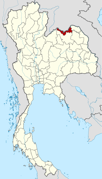
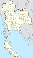
Deutsch: Lagekarte der Provinz Nong Khai, Thailand
English: Locator map of Nong Khai Province, Thailand |
| 日期 | |
| 來源 |
self-made, using |
| 作者 | NordNordWest |
| Other versions | Derivative works of this file: Thailand Bueng Kan locator map.svg |

|
This map has been made or improved in the German Kartenwerkstatt (Map Lab). You can propose maps to improve as well.
|
協議
I, the copyright holder of this work, hereby publish it under the following licenses:

|
根據自由軟體基金會發佈嘅無固定段落、封面文字同封底文字GNU自由文件授權條款第1.2或打後嘅版本,你獲授權可以重製、散佈同埋修改爾份文件。授權條款嘅副本喺章節GNU自由文件授權條款。 |
Ĉi tiu dosiero estas disponebla laŭ la permesilo Krea Komunaĵo Atribuite 3.0 Neadaptita.
- 你可以:
- 去分享 – 複製、發佈同傳播呢個作品
- 再改 – 創作演繹作品
- 要遵照下面嘅條件:
- 署名 – 你一定要畀合適嘅表彰、畀返指向呢個授權條款嘅連結,同埋寫明有無改過嚟。你可以用任何合理方式去做,但唔可以用任何方式暗示授權人認可咗你或者你嘅使用方式。
你可以揀你想用嘅牌照。
檔案歷史
撳個日期/時間去睇響嗰個時間出現過嘅檔案。
| 日期/時間 | 縮圖 | 尺寸 | 用戶 | 註解 | |
|---|---|---|---|---|---|
| 現時 | 2011年3月22號 (二) 10:51 | | 1,052 × 1,849(1.84 MB) | Ahoerstemeier | Updated version after Bueng Kan province was split off |
| 2009年4月21號 (二) 17:01 |  | 1,052 × 1,849(1.45 MB) | NordNordWest | {{Information |Description= {{de|Lagekarte der Provinz Nong Khai, Thailand}} {{en|Locator map of Nong Khai Province, Thailand}} |Source=self-made, using * Thailand location map.svg |Date=21-02-2009 |Author=[[User:NordN |
檔案用途
以下嘅1版用到呢個檔:
全域檔案使用情況
下面嘅維基都用緊呢個檔案:
- ar.wikipedia.org嘅使用情況
- be.wikipedia.org嘅使用情況
- bg.wikipedia.org嘅使用情況
- bo.wikipedia.org嘅使用情況
- bpy.wikipedia.org嘅使用情況
- cdo.wikipedia.org嘅使用情況
- ceb.wikipedia.org嘅使用情況
- ckb.wikipedia.org嘅使用情況
- de.wikipedia.org嘅使用情況
- de.wikivoyage.org嘅使用情況
- en.wikipedia.org嘅使用情況
- es.wikipedia.org嘅使用情況
- fa.wikipedia.org嘅使用情況
- fr.wikipedia.org嘅使用情況
- gl.wikipedia.org嘅使用情況
- hi.wikipedia.org嘅使用情況
- id.wikipedia.org嘅使用情況
- incubator.wikimedia.org嘅使用情況
- it.wikipedia.org嘅使用情況
- ja.wikipedia.org嘅使用情況
- ka.wikipedia.org嘅使用情況
- km.wikipedia.org嘅使用情況
- ko.wikipedia.org嘅使用情況
- lv.wikipedia.org嘅使用情況
- mg.wikipedia.org嘅使用情況
- nl.wikipedia.org嘅使用情況
- nn.wikipedia.org嘅使用情況
- ro.wikipedia.org嘅使用情況
- ru.wikipedia.org嘅使用情況
- sv.wikipedia.org嘅使用情況
- th.wikipedia.org嘅使用情況
- tl.wikipedia.org嘅使用情況
- tr.wikipedia.org嘅使用情況
- ur.wikipedia.org嘅使用情況
- vi.wikipedia.org嘅使用情況
- www.wikidata.org嘅使用情況
- zh.wikipedia.org嘅使用情況