
File:US insular areas-B.png

原本檔案 (1,482 × 624 像素,檔案大細:51 KB ,MIME類型:image/png)

|
File:US insular areas SVG.svg is a vector version of this file. It should be used in place of this PNG file when not inferior.
File:US insular areas-B.png → File:US insular areas SVG.svg
For more information, see Help:SVG. |
 |
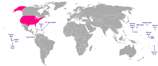
摘要
This is a map of the US Insular areas. The first version of this map was based off Image:BlankMap-World-v6.png by User:Astrokey44 with the locations of a few islands added; the source for this are two CIA maps; the maps are a map of the Pacific region and a map of the United States Pacific Island Wildlife Refuges. Hawaii has also been added to the map. Names of the islands are from the CIA Factbook. The second version is based off Image:Dependent_territories_2007.png by User:Sesmith.
For a version color-coded by each islands' status, see Image:US_insular_areas.png. For a version with the freely associated states, see Image:US_insular_areas-B FAS.png.
The previous map is under the GFDL; therefore, this map is too.
協議

|
根據自由軟體基金會發佈嘅無固定段落、封面文字同封底文字GNU自由文件授權條款第1.2或打後嘅版本,你獲授權可以重製、散佈同埋修改爾份文件。授權條款嘅副本喺章節GNU自由文件授權條款。 |
| 呢個檔案用共享創意 姓名標示-非商業性-相同方式分享3.0 未本地化版本條款授權。 | ||
| ||
| This licensing tag was added to this file as part of the GFDL licensing update. |
檔案歷史
撳個日期/時間去睇響嗰個時間出現過嘅檔案。
| 日期/時間 | 縮圖 | 尺寸 | 用戶 | 註解 | |
|---|---|---|---|---|---|
| 現時 | 2008年1月9號 (三) 11:10 | | 1,482 × 624(51 KB) | Hoshie | rebuilt using User:Sesmith's maps; more to come. |
| 2007年3月17號 (六) 10:43 |  | 1,482 × 624(32 KB) | Hoshie | This is a map of the US Insular areas. The base map is Image:BlankMap-World-v6.png by User:Astrokey44 with the locations of a few islands added; the source for this are two CIA maps; the maps are a [https://www.cia.gov/cia/publications/factbook/r |
檔案用途
無嘢連來呢份檔案。
全域檔案使用情況
下面嘅維基都用緊呢個檔案:
- en.wikipedia.org嘅使用情況
- kk.wikipedia.org嘅使用情況