
File:Waterloo Campaign map-alt3.svg

呢個「SVG」檔案嘅呢個「PNG」預覽嘅大細:527 × 599 像素。 第啲解像度:211 × 240 像素|422 × 480 像素|675 × 768 像素|900 × 1,024 像素|1,801 × 2,048 像素|1,500 × 1,706 像素。
原本檔案 (SVG檔案,表面大細: 1,500 × 1,706 像素,檔案大細:1.04 MB)
|
| Camera location | | View this and other nearby images on: OpenStreetMap |
|---|
摘要
| 描述 |
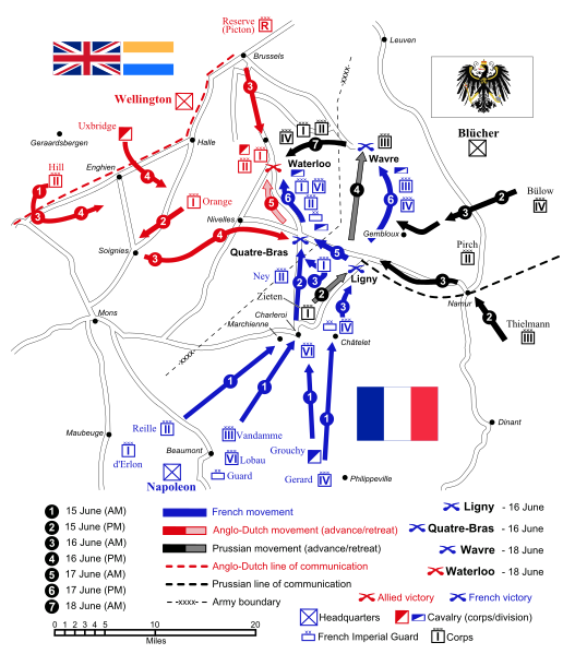
English: Map of force movements and major engagements during the Waterloo Campaign, June 15-18, 1815. Català: Mapa dels moviments i dels principals enfrontaments durant la Campanya de Waterloo, 15-18 de juny, 1815.
|
||||||||
| 日期 | |||||||||
| 來源 |
自己作品 (Original text: Self-made. Vectorized from raster image |
||||||||
| 作者 | Ipankonin | ||||||||
| 許可 (重用呢個檔案) |
I, the copyright holder of this work, hereby publish it under the following licenses:
This file is licensed under the Creative Commons Attribution-Share Alike 2.5 Generic, 2.0 Generic and 1.0 Generic license.
你可以揀你想用嘅牌照。 |
||||||||
| Other versions |
   |
||||||||
| SVG genesis | |||||||||
| SVG genesis |
|


檔案歷史
撳個日期/時間去睇響嗰個時間出現過嘅檔案。
| 日期/時間 | 縮圖 | 尺寸 | 用戶 | 註解 | |
|---|---|---|---|---|---|
| 現時 | 2008年1月24號 (四) 10:09 | | 1,500 × 1,706(1.04 MB) | Ipankonin | Reverted to version as of 08:39, 2 January 2008 |
| 2008年1月24號 (四) 10:07 |  | 1,500 × 1,706(1.04 MB) | Ipankonin | ||
| 2008年1月24號 (四) 10:05 |  | 1,500 × 1,706(1.04 MB) | Ipankonin | change background from an object to a document property | |
| 2008年1月2號 (三) 08:39 |  | 1,500 × 1,706(1.04 MB) | Ipankonin | slightly smaller nominal size | |
| 2008年1月2號 (三) 08:18 |  | 2,000 × 2,275(1.05 MB) | Ipankonin | larger nominal size | |
| 2008年1月1號 (二) 23:59 |  | 800 × 910(1.05 MB) | Ipankonin | {{Inkscape}} {{Information |Description= {{en|Map of force movements and major engagements during the Waterloo Campaign, June 15-18, 1815.}} |Source=Self-made. Vectorized from raster image 100px Flags from [[Image:Fl |
檔案用途
全域檔案使用情況
下面嘅維基都用緊呢個檔案:
- azb.wikipedia.org嘅使用情況
- ca.wikipedia.org嘅使用情況
- cs.wikipedia.org嘅使用情況
- da.wikipedia.org嘅使用情況
- de.wikipedia.org嘅使用情況
- el.wikipedia.org嘅使用情況
- en.wikipedia.org嘅使用情況
- Battle of Waterloo
- Napoleonic Wars
- Military strategy
- Battle of Ligny
- Hundred Days
- User talk:Gsl
- Battle of Quatre Bras
- Battle of Wavre
- Waterloo campaign
- Order of battle of the Waterloo campaign
- Portal:Maps/Selected picture
- Wikipedia:Featured pictures thumbs/09
- User talk:Ipankonin
- Napoleonic weaponry and warfare
- Wikipedia:Wikipedia Signpost/2008-01-07/Features and admins
- Wikipedia:Featured picture candidates/January-2008
- Wikipedia:Featured picture candidates/Waterloo Campaign Map
- Portal:Maps/Selected picture/33
- User talk:Ipankonin/Archive 3
- James Graham (British Army soldier)
- Wikipedia:Featured pictures/Diagrams, drawings, and maps/Maps
- Template:POTD/2008-06-15
- Wikipedia:Picture of the day/June 2008
- British Army during the Napoleonic Wars
- Jean Victor de Constant Rebecque
- Wikipedia:Wikipedia Signpost/2008-01-07/SPV
- Wikipedia:WikiProject Military history/Showcase
- Wikipedia:WikiProject Military history/Showcase/FP
- Talk:Battle of Waterloo/Archive 9
- Portal:Netherlands/Selected picture
- Wikipedia:WikiProject United States/Recognized content
- Wikipedia:WikiProject United States/Quality content
- Waterloo campaign: Quatre Bras to Waterloo
- User:NJInce/sandbox
- Wikipedia:WikiProject United States/Featured pictures
- Wikipedia:Wikipedia Signpost/Single/2008-01-07
睇呢個檔案嘅更多全域使用情況。