
File:People's Republic of China (orthographic projection).svg

呢個「SVG」檔案嘅呢個「PNG」預覽嘅大細:541 × 541 像素。 第啲解像度:240 × 240 像素|480 × 480 像素|768 × 768 像素|1,024 × 1,024 像素|2,048 × 2,048 像素。
原本檔案 (SVG檔案,表面大細: 541 × 541 像素,檔案大細:260 KB)
摘要
| 描述 |
Italiano: La Repubblica Popolare Cinese (in verde) e il territorio da essa dichiarato (in verde chiaro).
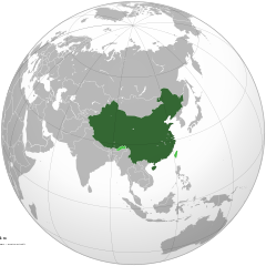
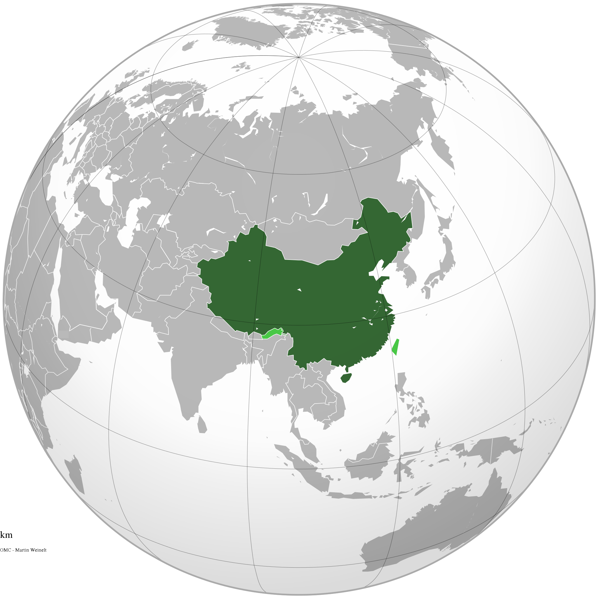
English: The People's Republic of China (green) and its claimed territory (lighter green).
Русский: Китайская Народная Республика (зелёный).
Українська: Територія Китаю позначена зеленим. Територія, на яку претендує Китай, але не контролює її, позначена світло-зеленим.
中文(简体):中华人民共和国(深绿色)及其认为拥有主权的地区(浅绿色)。
中文(繁體):中華人民共和國(深綠色)及其自認為擁有主權的地區(淺綠色)。 |
||||
| 日期 | |||||
| 來源 |
自己作品 (Original text: Own work)
|
||||
| 作者 | Ssolbergj | ||||
| Other versions |
.svg)
|
||||
| SVG genesis |
.jpg)
.svg)
.svg)
.svg)
.svg)
.svg)
.svg)
.svg)
.svg)
.svg)
.svg)
.svg)
.svg)
.svg)
.svg)
.svg)
.svg)
.svg)
.svg)
.svg)
.svg)
.svg)
.svg)
.svg)
.svg)
.svg)
.svg)
.svg)
.svg)
.svg)
.svg)
.svg)
.svg)
.svg)
.svg)
.svg)
.svg)
.svg)
.svg)
.svg)
.svg)
.svg)
.svg)
.svg)
.svg)
.svg)
.svg)
.svg)
.svg)
.svg)
.svg)
.svg)
.svg)
.svg)
.svg)
.svg)
.svg)
.svg)
.svg)
.svg)
.svg)
.svg)
.svg)
.svg)
.svg)
.svg)
.svg)
.svg)
.svg)
.svg)
.svg)
.svg)
.svg)
.svg)

.svg)

.svg)

.svg)
.svg)
.svg)
.svg)
.svg)
.svg)
.svg)


.svg)
.svg)
.svg)
.svg)
.svg)
.svg)
.svg)

.svg)
.svg)
.svg)
.svg)
.svg)
.svg)
.svg)
.svg)
.svg)

.svg)
.svg)
.svg)
.svg)
.svg)
.svg)
.svg)
_without_national_boundaries.svg)
.svg)
.svg)
.svg)
.svg)
.svg)
.svg)

.svg)
.svg)
.png)
.svg)
.svg)
.svg)
.svg)

.svg)
.svg)
.svg)
.svg)
.svg)
.svg)
.svg)
.svg)
.svg)
.svg)
.svg)

.svg)
.svg)
.svg)
.svg)
.svg)
.svg)
.svg)
.svg)
.svg)

.svg)
.svg)

.svg)
.svg)
.svg)
.svg)
.svg)
.svg)
.svg)
.svg)
.svg)
.svg)
.svg)
.svg)
.svg)
.svg)
.svg)
.svg)
.svg)
.svg)
.svg)
.svg)
.svg)
.svg)
.svg)
.svg)
.svg)
.svg)
.svg)
_-_Crimea_disputed.svg)
.svg)
.svg)
.svg)
.svg)
.svg)
.svg)
.svg)
.svg)
.svg)
.svg)
.svg)
_political.svg)
.svg)
.svg)
.svg)
.svg)
_-_Crimea_disputed_-_no_borders.svg)
.svg)
.svg)
.svg)
.svg)
.svg)
.svg)
.svg)
.svg)
.svg)
.svg)
.svg)

.svg)
.svg)
.svg)

.png)
.svg)
.svg)
.svg)
.svg)
.svg)
.svg)
.svg)
.svg)
.svg)
.svg)
.svg)
.svg)
.svg)
.svg)
.svg)
.svg)
.svg)
.svg)
.svg)
.svg)
.svg)
.svg)
.svg)
.svg)
.svg)
.svg)
.svg)
.svg)
.svg)
.svg)
.svg)
.svg)
.svg)
.svg)
.png)
.svg)
.svg)
.svg)
_(orthographic_projection).png)
.svg?uselang=yue)
.svg)
.svg)
協議
I, the copyright holder of this work, hereby publish it under the following licenses:

|
根據自由軟體基金會發佈嘅無固定段落、封面文字同封底文字GNU自由文件授權條款第1.2或打後嘅版本,你獲授權可以重製、散佈同埋修改爾份文件。授權條款嘅副本喺章節GNU自由文件授權條款。 |
This file is licensed under the Creative Commons Attribution-Share Alike 4.0 International, 3.0 Unported, 2.5 Generic, 2.0 Generic and 1.0 Generic license.
- 你可以:
- 去分享 – 複製、發佈同傳播呢個作品
- 再改 – 創作演繹作品
- 要遵照下面嘅條件:
- 署名 – 你一定要畀合適嘅表彰、畀返指向呢個授權條款嘅連結,同埋寫明有無改過嚟。你可以用任何合理方式去做,但唔可以用任何方式暗示授權人認可咗你或者你嘅使用方式。
- 相同方式分享 – 如果你用任何方式改過呢個作品,你必須要用返原本或者相似嘅條款發佈。
你可以揀你想用嘅牌照。
檔案歷史
撳個日期/時間去睇響嗰個時間出現過嘅檔案。
.svg&dir=prev)
.svg&offset=20111111220409)
.svg&offset=&limit=20)
.svg&offset=&limit=50)
.svg&offset=&limit=100)
.svg&offset=&limit=250)
.svg&offset=&limit=500)
| 日期/時間 | 縮圖 | 尺寸 | 用戶 | 註解 | |
|---|---|---|---|---|---|
| 現時 | 2019年12月29號 (日) 15:16 | | 541 × 541(260 KB) | Goran tek-en | Added border for South Sudan as requested by Maphobbyist |
| 2014年4月25號 (五) 06:05 |  | 541 × 541(142 KB) | Chipmunkdavis | Rv removal of claimed territories | |
| 2014年4月23號 (三) 16:05 |  | 541 × 541(498 KB) | Lawson123 | Reverted to version as of 17:14, 15 March 2014 | |
| 2014年3月15號 (六) 19:13 |  | 541 × 541(142 KB) | Chipmunkdavis | Rv removal of claimed territories | |
| 2014年3月15號 (六) 17:14 |  | 541 × 541(498 KB) | Semidwarf | Reverted to version as of 20:49, 14 March 2014 | |
| 2014年3月15號 (六) 00:14 |  | 541 × 541(142 KB) | Chipmunkdavis | Rv removal of claimed territories | |
| 2014年3月14號 (五) 20:49 |  | 541 × 541(498 KB) | Semidwarf | Reverted to version as of 14:49, 9 April 2011 | |
| 2014年3月14號 (五) 20:48 |  | 541 × 541(498 KB) | Semidwarf | Reverted to version as of 14:49, 9 April 2011 | |
| 2012年9月12號 (三) 21:53 |  | 541 × 541(142 KB) | Palosirkka | Scrubbed with http://codedread.com/scour/ | |
| 2011年11月11號 (五) 22:04 |  | 541 × 541(481 KB) | Gucong | According to http://en.wikipedia.org/wiki/Wikipedia:WikiProject_Maps/Conventions/Orthographic_maps , claimed areas shall be marked as light green |
檔案用途
全域檔案使用情況
下面嘅維基都用緊呢個檔案:
- af.wikipedia.org嘅使用情況
- ami.wikipedia.org嘅使用情況
- arc.wikipedia.org嘅使用情況
- ar.wikipedia.org嘅使用情況
- as.wikipedia.org嘅使用情況
- av.wikipedia.org嘅使用情況
- azb.wikipedia.org嘅使用情況
- az.wikipedia.org嘅使用情況
- az.wiktionary.org嘅使用情況
- ban.wikipedia.org嘅使用情況
- ba.wikipedia.org嘅使用情況
- bcl.wikipedia.org嘅使用情況
- beta.wikiversity.org嘅使用情況
- be.wikipedia.org嘅使用情況
- bh.wikipedia.org嘅使用情況
- bn.wikipedia.org嘅使用情況
- cdo.wikipedia.org嘅使用情況
- cs.wikipedia.org嘅使用情況
- cu.wikipedia.org嘅使用情況
- da.wikipedia.org嘅使用情況
- de.wiktionary.org嘅使用情況
- dty.wikipedia.org嘅使用情況
- dz.wikipedia.org嘅使用情況
- el.wikipedia.org嘅使用情況
- el.wikinews.org嘅使用情況
- Το Διεθνές Νομισματικό Ταμείο προειδοποεί τη Κίνα για το γουάν
- Πρότυπο:Κίνα
- Ατύχημα με 41 νεκρούς στη Κίνα
- Κίνα: Η στήριξη της Ελλάδας αποτελεί σημαντικό βήμα για την Ευρωζώνη
- Συνεχίζονται οι απεργίες των ταξί στη Κίνα
- Πενηντατέσσερις αμαξοστοιχίες ανακαλούνται στην Κίνα για λόγους ασφαλείας
- Η Coca-Cola θα επενδύσει 4 δισεκατομμύρια δολάρια στη Κίνα για τα επόμενα 3 έτη
- Διασώθηκαν 19 παγιδευμένοι ανθρακωρύχοι στη Κίνα
- Ήπια ενίσχυση της μεταποίησης στη Κίνα
- Δέκα ανθρακωρύχοι ανασύρθηκαν νεκροί από ορυχείο της Κίνας
- Ανακαλύφθηκε τάφος με 12 άλογα στη Κίνα
- Έντεκα άτομα σκοτώθηκαν σε ναυάγιο στη Κίνα
- Κίνα: Δεκάδες νεκροί και αγνοούμενοι ύστερα από ισχυρές βροχοπτώσεις
- Κρούσματα πολιομυελίτιδας στην Κίνα για πρώτη φορά από το 1999
- Στη Κίνα συνελήφθη άνδρας που βίαζε στο υπόγειο έξι γυναίκες για δύο χρόνια
- Σανγκάη: Εκατοντάδες τραυματίες σε σύγκρουση συρμών του μετρό
- Στην Κίνα ο Βλαντιμίρ Πούτιν
睇呢個檔案嘅更多全域使用情況。
.svg)
.svg)