
File:Surface-to-Air Missile Coverage over the Taiwan Strait.png
預覽大細:588 × 600 像素。 第啲解像度:235 × 240 像素|470 × 480 像素|738 × 753 像素。
原本檔案 (738 × 753 像素,檔案大細:104 KB ,MIME類型:image/png)

|
This map image could be recreated using vector graphics as an SVG file. This has several advantages; see Commons:Media for cleanup for more information. If an SVG form of this image is already available, please upload it. After uploading an SVG, replace this template with {{vector version available|new image name.svg}}.
|
| 描述 |
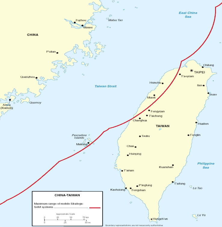
Figure 7. Surface-to-Air Missile Coverage over the Taiwan Strait. Note: This map depicts notional coverage provided by China’s SA-10, SA-20 SAM systems, as well as the soon-to-be acquired S-300PMU2. Actual coverage would be non-contiguous and dependent upon precise deployment sites. |
|||
| 日期 | 05/23/06 | |||
| 來源 | Image:China Report 2006.pdf | |||
| 作者 | DoD | |||
| 許可 (重用呢個檔案) |
|
|||
| Other versions | Derivative works of this file: Surface-to-Air Missile Coverage over the Taiwan Strait-ar.png |

檔案歷史
撳個日期/時間去睇響嗰個時間出現過嘅檔案。
| 日期/時間 | 縮圖 | 尺寸 | 用戶 | 註解 | |
|---|---|---|---|---|---|
| 現時 | 2018年3月8號 (四) 22:15 | | 738 × 753(104 KB) | Ras67 | new extracted, cleaned and cropped from PDF |
| 2006年5月26號 (五) 08:40 |  | 769 × 773(256 KB) | Shizhao | {{Information |Description=Figure 7. Surface-to-Air Missile Coverage over the Taiwan Strait. Note: This map depicts notional coverage provided by China’s SA-10, SA-20 SAM systems, as well as the soon-to-be acquired S-300PMU2. Actual coverage would be n |
檔案用途
以下嘅1版用到呢個檔:
全域檔案使用情況
下面嘅維基都用緊呢個檔案:
- en.wikipedia.org嘅使用情況
- es.wikipedia.org嘅使用情況
- hu.wikipedia.org嘅使用情況
- ja.wikipedia.org嘅使用情況
- ko.wikipedia.org嘅使用情況
- nov.wikipedia.org嘅使用情況
- pt.wikipedia.org嘅使用情況
- vi.wikipedia.org嘅使用情況
- zh.wikipedia.org嘅使用情況