
File:Association of Southeast Asian Nations (orthographic projection).svg

呢個「SVG」檔案嘅呢個「PNG」預覽嘅大細:550 × 551 像素。 第啲解像度:240 × 240 像素|479 × 480 像素|767 × 768 像素|1,022 × 1,024 像素|2,044 × 2,048 像素。
原本檔案 (SVG檔案,表面大細: 550 × 551 像素,檔案大細:411 KB)
摘要
| 描述 |
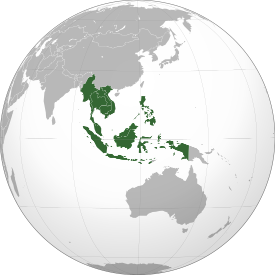
English: Association of Southeast Asian Nations in orthographic projection. |
||||
| 日期 | |||||
| 來源 |
自己作品
|
||||
| 作者 | Addicted04 | ||||
| Other versions |
.svg) |
||||
| SVG genesis |

.svg)
.svg)
.svg)
.svg)
.svg)
.svg)
.svg)
.svg)
.svg)
.svg)
.svg)
.svg)
.svg)
.svg)
.svg)
.svg)
.svg)
.svg)
.svg)
.svg)
.svg)
.svg)
.svg)
.svg)
.svg)
.svg)
.svg)
.svg)
.svg)
.svg)
.svg)
.svg)
.svg)
.svg)
.svg)
.svg)
.svg)
.svg)
.svg)
.svg)
.svg)
.svg)
.svg)
.svg)
.svg)
.svg)
.svg)
.svg)
.svg)
.svg)
.svg)
.svg)
.svg)
.svg)
.svg)
.svg)
.svg)
.svg)
.svg)
.svg)
.svg)
.svg)
.svg)
.svg)
.svg)
.svg)
.svg)
.svg)
.svg)
.svg)
.svg)
.svg)
.svg)

.svg)

.svg)

.svg)
.svg)
.svg)
.svg)
.svg)
.svg)
.svg)


.svg)
.svg)
.svg)
.svg)
.svg)
.svg)
.svg)

.svg)
.svg)
.svg)
.svg)
.svg)
.svg)
.svg)
.svg)
.svg)

.svg)
.svg)
.svg)
.svg)
.svg)
.svg)
.svg)
_without_national_boundaries.svg)
.svg)
.svg)
.svg)
.svg)
.svg)
.svg)

.svg)
.svg)
.png)
.svg)
.svg)
.svg)
.svg)

.svg)
.svg)
.svg)
.svg)
.svg)
.svg)
.svg)
.svg)
.svg)
.svg)
.svg)

.svg)
.svg)
.svg)
.svg)
.svg)
.svg)
.svg)
.svg)
.svg)

.svg)
.svg)

.svg)
.svg)
.svg)
.svg)
.svg)
.svg)
.svg)
.svg)
.svg)
.svg)
.svg)
.svg)
.svg)
.svg)
.svg)
.svg)
.svg)
.svg)
.svg)
.svg)
.svg)
.svg)
.svg)
.svg)
.svg)
.svg)
.svg)
_-_Crimea_disputed.svg)
.svg)
.svg)
.svg)
.svg)
.svg)
.svg)
.svg)
.svg)
.svg)
.svg)
.svg)
_political.svg)
.svg)
.svg)
.svg)
.svg)
_-_Crimea_disputed_-_no_borders.svg)
.svg)
.svg)
.svg)
.svg)
.svg)
.svg)
.svg)
.svg)
.svg)
.svg)
.svg)

.svg)
.svg)
.svg)

.png)
.svg)
.svg)
.svg)
.svg)
.svg)
.svg)
.svg)
.svg)
.svg)
.svg)
.svg)
.svg)
.svg)
.svg)
.svg)
.svg)
.svg)
.svg)
.svg)
.svg)
.svg)
.svg)
.svg)
.svg)
.svg)
.svg)
.svg)
.svg)
.svg)
.svg)
.svg)
.svg)
.svg)
.svg)
.png)
.svg)
.svg)
.svg)
_(orthographic_projection).png)
.svg?uselang=yue)
協議
我,呢份作品嘅作者,決定用以下許可發佈呢件作品:
Ĉi tiu dosiero estas disponebla laŭ la permesilo Krea Komunaĵo Atribuite 3.0 Neadaptita.
- 你可以:
- 去分享 – 複製、發佈同傳播呢個作品
- 再改 – 創作演繹作品
- 要遵照下面嘅條件:
- 署名 – 你一定要畀合適嘅表彰、畀返指向呢個授權條款嘅連結,同埋寫明有無改過嚟。你可以用任何合理方式去做,但唔可以用任何方式暗示授權人認可咗你或者你嘅使用方式。
檔案歷史
撳個日期/時間去睇響嗰個時間出現過嘅檔案。
.svg&dir=prev)
.svg&offset=20190331035617)
.svg&offset=&limit=20)
.svg&offset=&limit=50)
.svg&offset=&limit=100)
.svg&offset=&limit=250)
.svg&offset=&limit=500)
| 日期/時間 | 縮圖 | 尺寸 | 用戶 | 註解 | |
|---|---|---|---|---|---|
| 現時 | 2022年12月4號 (日) 23:36 | | 550 × 551(411 KB) | Maphobbyist | East Timor is not a member of Asean. The country only became an observer. |
| 2022年11月28號 (一) 12:39 |  | 550 × 551(414 KB) | JGNTHA | Reverted to version as of 06:06, 13 November 2022 (UTC) | |
| 2022年11月14號 (一) 20:13 |  | 550 × 551(411 KB) | Multituberculata | East Timor has not become a member of Asean. It has only become an observer. | |
| 2022年11月13號 (日) 06:06 |  | 550 × 551(414 KB) | -tynjee | timor leste joins asean on 11 november | |
| 2021年7月2號 (五) 04:00 |  | 550 × 551(411 KB) | PyroFloe | Reverted to version as of 05:23, 31 March 2019 (UTC) The map should not have an outline as every other map of this kind doesn't. Please use the previous template and just add the observer states without modifying anything else | |
| 2021年5月24號 (一) 08:29 |  | 407 × 407(8.14 MB) | EC 2021 | Minor edit | |
| 2021年5月23號 (日) 07:29 |  | 3,545 × 3,545(21.23 MB) | EC 2021 | Timor-Leste and Papua New Guinea are added as observer states | |
| 2019年3月31號 (日) 05:23 |  | 550 × 551(411 KB) | Viva Nicolás | Oecusse | |
| 2019年3月31號 (日) 04:56 |  | 550 × 551(411 KB) | Viva Nicolás | Remove Andaman & Nicobar Islands. | |
| 2019年3月31號 (日) 03:56 |  | 550 × 551(411 KB) | Viva Nicolás | Fix shading. |
檔案用途
全域檔案使用情況
下面嘅維基都用緊呢個檔案:
- ace.wikipedia.org嘅使用情況
- af.wikipedia.org嘅使用情況
- ar.wikipedia.org嘅使用情況
- ast.wikipedia.org嘅使用情況
- as.wikipedia.org嘅使用情況
- bcl.wikipedia.org嘅使用情況
- be-tarask.wikipedia.org嘅使用情況
- be.wikipedia.org嘅使用情況
- bg.wikipedia.org嘅使用情況
- blk.wikipedia.org嘅使用情況
- bn.wikipedia.org嘅使用情況
- ckb.wikipedia.org嘅使用情況
- crh.wikipedia.org嘅使用情況
- da.wikipedia.org嘅使用情況
- de.wikipedia.org嘅使用情況
- el.wikipedia.org嘅使用情況
- en.wikipedia.org嘅使用情況
- ASEAN
- ASEAN Summit
- Sinosphere
- Category:Vietnamese Wikipedians
- ASEAN Charter
- List of regional organizations by population
- Template:User Tambayan Philippines
- Template:User WP Cambodia
- Template:User interest Vietnam
- Template:User interest Vietnam/doc
- Template:User WP Vietnam
- Template:User WP Vietnam/doc
- Template:User from the Philippines
- Template:User in Myanmar
- Template:User in Myanmar/doc
- Template:User in Cambodia
- Template:User in Cambodia/doc
- Template:User in Vietnam
- Template:User in Vietnam/doc
- Template:User WP Burma
- Template:User WP Burma/doc
- Template:User WP Myanmar
- Template:User WP Myanmar/doc
- Template:User WP Cambodia/doc
- Template:User in Laos
- Template:User in Laos/doc
- Template:User WP Laos
- Template:User WP Laos/doc
- Template:User in the Philippines
- Template:User in the Philippines/doc
- Template:User interest Burma
- Template:User interest Burma/doc
睇呢個檔案嘅更多全域使用情況。
.svg)
.svg)