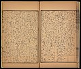
File:皇清地理圖八十一及八十二.jpg
原本檔案 (4,096 × 3,463 像素,檔案大細:2.68 MB ,MIME類型:image/jpeg)
檔案歷史
撳個日期/時間去睇響嗰個時間出現過嘅檔案。
| 日期/時間 | 縮圖 | 尺寸 | 用戶 | 註解 | |
|---|---|---|---|---|---|
| 現時 | 2018年3月15號 (四) 13:49 |  | 4,096 × 3,463(2.68 MB) | HenryLi | User created page with UploadWizard |
檔案用途
以下嘅1版用到呢個檔:
原本檔案 (4,096 × 3,463 像素,檔案大細:2.68 MB ,MIME類型:image/jpeg)
| 描述皇清地理圖八十一及八十二.jpg |
中文(繁體):《皇清地理圖》清董祐誠撰。董祐誠(1791—1823年),字方立,江蘇陽湖(今屬江蘇常州)人,清代數學家。原題為董氏據康熙、乾隆兩朝之內府輿圖精心仿繪,並博稽掌故,旁羅方志,自乾隆以來州縣之更改,水道之變遷,皆參校確實而著之,而繼至道光二年(1822年)。所收東費雅喀(清東北少數民族名稱),西極蔥嶺,北界俄羅斯,南至於海,分為四十一圖,於道光十二年(1832年)由陽湖李兆洛之辨志書塾鋟版。流布海內二十餘年。原板漸模糊,且紙幅頗大,咸豐六年(1856年)長沙胡錫燕將此圖覆刻,改為書版型式。版心上題書名,下題篇目名,如 「總圖」、「黑龍江」、「科布多」,下方記頁次。所繪地圖,按里計方,版心下端皆記有該圖在總圖中之位置,如吉林 「橫三縱二」,車臣 「橫三縱五」 等。地圖正文橫五格,縱八格。卷首書名頁後有 「皇清地理總圖」 六字。刻工精良,維妙維肖,即如地圖之繁富,亦毫釐不爽。總圖右上角注雲 「每方二百里」。原封面不存。書根題書名,並注一全字。本書再據以覆刻。全書九十一葉。內地圖凡八十八葉。總計中國清道光時南北凡緯度相距四十三度,東西凡經度相距七十七度,計里定方,南北八千六百里,東西一萬一千五百里。全國共十九省,一百八十五府,十九直隸廳,七十五散廳,六十九直隸州,一百七十一散州,一千三百另四縣,另將軍等所駐城三十一,防守等所駐城四十八,卡倫一百七十六。書末第八十九至九十一葉簡述行政制度、疆土大小、印行及翻刻。末頁底有 「廣東省城學院前藝芳齋刊印」。 |
| 日期 | |
| 來源 | https://www.wdl.org/zh/item/19483/ |
| 作者 | 董祐誠 |
|
This is a faithful photographic reproduction of a two-dimensional, public domain work of art. The work of art itself is in the public domain for the following reason:
The official position taken by the Wikimedia Foundation is that "faithful reproductions of two-dimensional public domain works of art are public domain".
This photographic reproduction is therefore also considered to be in the public domain in the United States. In other jurisdictions, re-use of this content may be restricted; see Reuse of PD-Art photographs for details. | |||||
撳個日期/時間去睇響嗰個時間出現過嘅檔案。
| 日期/時間 | 縮圖 | 尺寸 | 用戶 | 註解 | |
|---|---|---|---|---|---|
| 現時 | 2018年3月15號 (四) 13:49 |  | 4,096 × 3,463(2.68 MB) | HenryLi | User created page with UploadWizard |
以下嘅1版用到呢個檔: