
File:13-09-29-nordfriesisches-wattenmeer-RalfR-05.jpg
原本檔案 (4,145 × 1,798 像素,檔案大細:3.94 MB ,MIME類型:image/jpeg)
摘要
| 描述 |
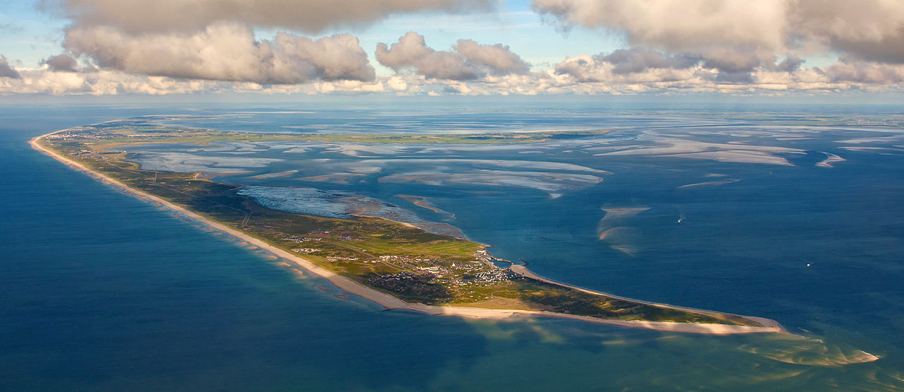
Čeština: Fotografie z letu nad Waddenzee u Severofríských ostrovů, pohled z jiho-jihozápadu (200 °), výška 1 km, vzdálenost 4 km od ostrova Sylt Deutsch: Fotoflug über das nordfriesische Wattenmeer, Blick aus SSW (200°), 1 km Höhe und 4 km Entfernung auf Sylt English: Photo flight over the North Frisian Wadden Sea, view from SSW (200 °), 1 km altitude and 4 km distance to Sylt Español: Foto vuelo sobre el Mar de Wadden de Frisia del Norte, vista desde el 1 kilometro de altura ya 4 km de Sylt Français : Vue aérienne des Îles frisonnes septentrionales du parc national de la mer des Wadden du Schleswig-Holstein. Vue à SSO (200 °), 1 km d'altitude et à 4 km de distance de Sylt. |
|||||||||||||||||||||||
| 日期 | ||||||||||||||||||||||||
| 來源 | 自己作品 | |||||||||||||||||||||||
| 作者 |
|
|||||||||||||||||||||||
| 許可 (重用呢個檔案) |
|
|||||||||||||||||||||||

| Camera location | | View this and other nearby images on: OpenStreetMap |
|---|
|
This image was selected as picture of the day on Wikimedia Commons for 29 March 2014. It was captioned as follows: English: Photo flight over the North Frisian Wadden Sea, view from SSW (200°), 1 km altitude and 4 km distance to Sylt Other languages:
Bosanski: Panoramski let iznad sjeverofrizijske obale u Njemačkoj, pogled sa jug-jugozapada sa visine 1km i udaljenosti 4km od ostrva Sylt Čeština: Letecký snímek ostrova Sylt ze skupiny Severofríských ostrovů, pohled z jiho-jihozápadu (SSW, 200 °) English: Photo flight over the North Frisian Wadden Sea, view from SSW (200°), 1 km altitude and 4 km distance to Sylt Italiano: Foto aerea delle Isole Frisone Settentrionali nel Mare dei Wadden, vista da SSW (200 °), da 1 km di altitudine e 4 km di distanza da Sylt Magyar: Légi fotó dél-délnyugat felől, 1 km magasból és 4 km távolságról Sylt szigetéről (Németország, Északi-Fríz-szigetek) Nederlands: Een vlucht over de Noord-Friese Waddeneilanden op een hoogte van 1000 meter en op vier kilometer afstand van het Duitse Waddeneiland Sylt. 中文: 北弗里西亚群岛俯拍照。 |
協議
I, the copyright holder of this work, hereby publish it under the following licenses:

|
根據自由軟體基金會發佈嘅無固定段落、封面文字同封底文字GNU自由文件授權條款第1.2或打後嘅版本,你獲授權可以重製、散佈同埋修改爾份文件。授權條款嘅副本喺章節GNU自由文件授權條款。 |
This file is licensed under the Creative Commons Attribution-Share Alike 3.0 Unported, 2.5 Generic, 2.0 Generic and 1.0 Generic license.
- 你可以:
- 去分享 – 複製、發佈同傳播呢個作品
- 再改 – 創作演繹作品
- 要遵照下面嘅條件:
- 署名 – 你一定要畀合適嘅表彰、畀返指向呢個授權條款嘅連結,同埋寫明有無改過嚟。你可以用任何合理方式去做,但唔可以用任何方式暗示授權人認可咗你或者你嘅使用方式。
- 相同方式分享 – 如果你用任何方式改過呢個作品,你必須要用返原本或者相似嘅條款發佈。
你可以揀你想用嘅牌照。

- Weiternutzung dieses Fotos
- Wenn Sie dieses Foto im Internet verwenden möchten, bitte ich um Verlinkung meiner privaten Homepage: www.fahrradmonteur.de.
Sie können das Bild unter einer der unten angegebenen Lizenzen frei verwenden, dabei ist keine Gebühr zu entrichten. Eine kommerzielle Verwendung dieses Fotos ist ebenfalls möglich, dabei sind außer den u. g. Lizenzbestimmungen keine gesonderten Bedingungen zu beachten.
| Dieses Foto entstand aufgrund eines Projektes, das von Wikimedia Deutschland e. V. gefördert wurde.
Im Rahmen des „Community-Projektbudgets“ sollen Luftbilder u.a. von Inseln, Halligen, Sanden und Küstenstädten der deutschen Nordseeküste angefertigt werden. Das Projekt „Fotoflüge“ wurde im September 2011 begonnen. |
| Annotations | This image is annotated: View the annotations at Commons |
檔案歷史
撳個日期/時間去睇響嗰個時間出現過嘅檔案。
| 日期/時間 | 縮圖 | 尺寸 | 用戶 | 註解 | |
|---|---|---|---|---|---|
| 現時 | 2013年11月4號 (一) 12:37 |  | 4,145 × 1,798(3.94 MB) | Ralf Roletschek | {{Information |Description= |Source= |Date= |Author= |Permission= |other_versions= }} |
| 2013年10月2號 (三) 16:42 |  | 4,145 × 1,798(3.92 MB) | Ralf Roletschek |
檔案用途
無嘢連來呢份檔案。
全域檔案使用情況
下面嘅維基都用緊呢個檔案:
- ar.wikipedia.org嘅使用情況
- arz.wikipedia.org嘅使用情況
- ast.wikipedia.org嘅使用情況
- be-tarask.wikipedia.org嘅使用情況
- be.wikipedia.org嘅使用情況
- bg.wikipedia.org嘅使用情況
- bn.wikipedia.org嘅使用情況
- br.wikipedia.org嘅使用情況
- ca.wikipedia.org嘅使用情況
- ceb.wikipedia.org嘅使用情況
- crh.wikipedia.org嘅使用情況
- cs.wikipedia.org嘅使用情況
- cv.wikipedia.org嘅使用情況
- da.wikipedia.org嘅使用情況
- de.wikipedia.org嘅使用情況
- de.wikiversity.org嘅使用情況
- de.wikivoyage.org嘅使用情況
- dsb.wikipedia.org嘅使用情況
- el.wikipedia.org嘅使用情況
- en.wikipedia.org嘅使用情況
- en.wikivoyage.org嘅使用情況
睇呢個檔案嘅更多全域使用情況。