跳去內容

File:1806 Cary Map of Tartary or Central Asia - Geographicus - Tartary-cary-1806.jpg

頁面內容唔支援其他語言。
出自維基百科,自由嘅百科全書

原本檔案 (5,000 × 4,569 像素,檔案大細:8.57 MB ,MIME類型:image/jpeg

John Cary:A New Map of Mongolian & Independent Tartary , From the Latest Authorities.   (Wikidata search (Cirrus search) Wikidata query (SPARQL)  Create new Wikidata item based on this file)
Artist
John Cary  (1755–1835)  wikidata:Q3446124 s:en:Author:John Cary
 
Alternative names
J. Cary
Description cartographer、printmaker、mapseller、printseller 同埋globe maker
Date of birth/death 1755年2月23號 改維基數據 1835年8月16號 改維基數據
Location of birth/death Corsley 改維基數據 Mortlake 改維基數據
Work period 1779年 改維基數據–1835年 改維基數據
Work location
權威控制
artist QS:P170,Q3446124
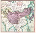
A New Map of Mongolian & Independent Tartary , From the Latest Authorities.
描述
English: An exceptionally beautiful example of John Cary’s important 1806 map of Mongolian and Independent Tartary. Covers Central Asia from the Caspian Sea to Japan, extends as far north as the Obskaia Sea and as far south as India, Burma and the Philippines. Includes the modern day nations of Uzbekistan, Kazakhstan, Turkmenistan, Kirgizstan, Tajikistan and Mongolia. One of Cary’s most interesting maps. Central Asia, despite hundreds of years of passing trade on the Silk Routes, was still, at the turn of the century a largely unknown land. Cary attempts to show some of the Silk Route passages, especially to the north of the Gobi, but ultimately admits, “The Geography of these parts is extremely obscure.” All in all, one of the most interesting and few maps of Central Asia to appear in first years of the 19th century. Prepared in 1806 by John Cary for issue in his magnificent 1808 New Universal Atlas. (NOTE: The reproduction of the colors in this map appear to be incorrect, as Japan and Tibet were never part of Chinese Tartary yet appear to be the same color as it.)
日期 1806年 (dated)
Dimensions 高度:18.5in(46.9cm);闊度:20in(50.8cm)
dimensions QS:P2048,18.5U218593
dimensions QS:P2049,20U218593
Accession number
Geographicus link: Tartary-cary-1806
Source/Photographer

Cary, John, Cary's New Universal Atlas, containing distinct maps of all the principal states and kingdoms throughout the World. From the latest and best authorities extant. London: Printed for J. Cary, Engraver and Map-seller, No. 181, near Norfolk Street, Strand, 1808.

許可
(重用呢個檔案)
This is a faithful photographic reproduction of a two-dimensional, public domain work of art. The work of art itself is in the public domain for the following reason:
Public domain

呢個作品喺來源國同埋其他版權期限係作者過身後100年或以下嘅國家同地區屬於公有領域


You must also include a United States public domain tag to indicate why this work is in the public domain in the United States.
This file has been identified as being free of known restrictions under copyright law, including all related and neighboring rights.
The official position taken by the Wikimedia Foundation is that "faithful reproductions of two-dimensional public domain works of art are public domain".
This photographic reproduction is therefore also considered to be in the public domain in the United States. In other jurisdictions, re-use of this content may be restricted; see Reuse of PD-Art photographs for details.
Other versions
Annotations
InfoField
This image is annotated: View the annotations at Commons

Captions

Add a one-line explanation of what this file represents

Items portrayed in this file

圖中顯示嘅係

image/jpeg

3d7f1be3ae7a9539d26d91394bee37e7dc951779

8,990,511 字節

4,569 像素

5,000 像素

檔案歷史

撳個日期/時間去睇響嗰個時間出現過嘅檔案。

日期/時間縮圖尺寸用戶註解
現時2019年8月19號 (一) 08:56響2019年8月19號 (一) 08:56嘅縮圖版本5,000 × 4,569(8.57 MB)SoerfmBrightness, color
2011年3月22號 (二) 10:56響2011年3月22號 (二) 10:56嘅縮圖版本5,000 × 4,569(7.81 MB)BotMultichillT{{subst:User:Multichill/Geographicus |link=http://www.geographicus.com/P/AntiqueMap/Tartary-cary-1806 |product_name=1806 Cary Map of Tartary or Central Asia |map_title=A New Map of Chinese & Independent Tartary , From the Latest Authorities. |description=

以下嘅1版用到呢個檔:

全域檔案使用情況

下面嘅維基都用緊呢個檔案:

Metadata