
File:Aerial view of Porirua City Centre and Porirua Station.jpg

原本檔案 (5,145 × 3,434 像素,檔案大細:7.05 MB ,MIME類型:image/jpeg)
摘要
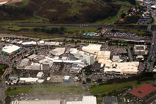
| 描述 | Viewed from west, with considerable visible detail at 100%. In upper right with the crowded parking lot is Porirua Station. North City Shopping Centre is on right (tan colored building with Kmart and Farmer's logo). State Highway 1 (SH 1N) and railway are at top. Green-walled building on left is a Countdown supermarket. |
| 日期 | |
| 來源 | Aerial view of Porirua City Centre and Porirua Station |
| 作者 | Derrick Coetzee (User:Dcoetzee) |
| Camera location | | View this and other nearby images on: OpenStreetMap |
|---|
協議
| This file is made available under the Creative Commons CC0 1.0 Universal Public Domain Dedication. | |
| The person who associated a work with this deed has dedicated the work to the public domain by waiving all of their rights to the work worldwide under copyright law, including all related and neighboring rights, to the extent allowed by law. You can copy, modify, distribute and perform the work, even for commercial purposes, all without asking permission.
|
| This image, originally posted to Flickr, was reviewed on 14 September 2013 by the administrator or reviewer Dcoetzee, who confirmed that it was available on Flickr under the stated license on that date. |
檔案歷史
撳個日期/時間去睇響嗰個時間出現過嘅檔案。
| 日期/時間 | 縮圖 | 尺寸 | 用戶 | 註解 | |
|---|---|---|---|---|---|
| 現時 | 2013年9月14號 (六) 05:33 | | 5,145 × 3,434(7.05 MB) | Dcoetzee | Transferred from Flickr by User:Dcoetzee using flickr2commons |
檔案用途
以下嘅1版用到呢個檔:
全域檔案使用情況
下面嘅維基都用緊呢個檔案:
- ar.wikipedia.org嘅使用情況
- arz.wikipedia.org嘅使用情況
- avk.wikipedia.org嘅使用情況
- ca.wikipedia.org嘅使用情況
- de.wikivoyage.org嘅使用情況
- en.wikipedia.org嘅使用情況
- en.wikivoyage.org嘅使用情況
- es.wikipedia.org嘅使用情況
- hi.wikipedia.org嘅使用情況
- it.wikipedia.org嘅使用情況
- ja.wikipedia.org嘅使用情況
- ka.wikipedia.org嘅使用情況
- ko.wikipedia.org嘅使用情況
- no.wikipedia.org嘅使用情況
- pl.wikipedia.org嘅使用情況
- ru.wikipedia.org嘅使用情況
- simple.wikipedia.org嘅使用情況
- tr.wikipedia.org嘅使用情況
- uk.wikipedia.org嘅使用情況
- vo.wikipedia.org嘅使用情況
- www.wikidata.org嘅使用情況
- zh.wikipedia.org嘅使用情況