
File:Aralskoje more.gif
預覽大細:409 × 600 像素。 第啲解像度:163 × 240 像素|557 × 817 像素。
原本檔案 (557 × 817 像素,檔案大細:490 KB ,MIME類型:image/gif、循環、7格、15 s)
摘要
| 描述 |
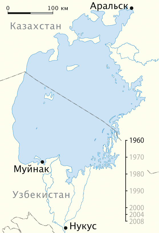
Deutsch: Animierte Karte des Austrocknens des Aralsees, russische Version
English: Animated map of the shrinking of the Aral Sea, Russian version
Русский: Анимированная карта обмеления Аральского моря, русская версия |
| 日期 | 11-04-2008 |
| 來源 |
自己作品, using
|
| 作者 | NordNordWest |
| Other versions |
|

|
This map has been made or improved in the German Kartenwerkstatt (Map Lab). You can propose maps to improve as well.
|
協議
I, the copyright holder of this work, hereby publish it under the following licenses:

|
根據自由軟體基金會發佈嘅無固定段落、封面文字同封底文字GNU自由文件授權條款第1.2或打後嘅版本,你獲授權可以重製、散佈同埋修改爾份文件。授權條款嘅副本喺章節GNU自由文件授權條款。 |
呢個檔案用共享創意 姓名標示-非商業性-相同方式分享3.0 未本地化版本條款授權。
- 你可以:
- 去分享 – 複製、發佈同傳播呢個作品
- 再改 – 創作演繹作品
- 要遵照下面嘅條件:
- 署名 – 你一定要畀合適嘅表彰、畀返指向呢個授權條款嘅連結,同埋寫明有無改過嚟。你可以用任何合理方式去做,但唔可以用任何方式暗示授權人認可咗你或者你嘅使用方式。
- 相同方式分享 – 如果你用任何方式改過呢個作品,你必須要用返原本或者相似嘅條款發佈。
你可以揀你想用嘅牌照。
檔案歷史
撳個日期/時間去睇響嗰個時間出現過嘅檔案。
| 日期/時間 | 縮圖 | 尺寸 | 用戶 | 註解 | |
|---|---|---|---|---|---|
| 現時 | 2009年1月7號 (三) 18:43 | | 557 × 817(490 KB) | Hk kng | Size optimization |
| 2008年4月11號 (五) 14:53 |  | 557 × 817(1.04 MB) | NordNordWest | == Beschreibung == {{Information |Description= {{de}} Animierte Karte des Austrocknens des Aralsees, russische Version {{en}} Animated map of the shrinking of the Aral Sea, Russian version |Source=own work, using * NASA |
檔案用途
無嘢連來呢份檔案。
全域檔案使用情況
下面嘅維基都用緊呢個檔案:
- be-tarask.wikipedia.org嘅使用情況
- kk.wikipedia.org嘅使用情況