
File:British map of Canton, 1840.jpg
原本檔案 (525 × 800 像素,檔案大細:153 KB ,MIME類型:image/jpeg)
摘要
| 描述 |
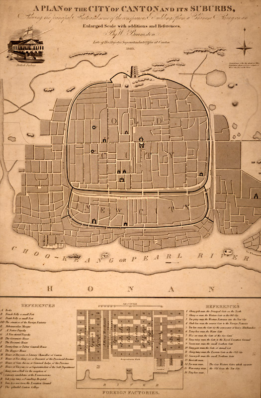
English: A plan of the city of Canton and its suburbs. REFERENCES A Rocks B French Folly a small Fort C Dutch Folly a small Fort DD The situation of the Foreign Factories E Mehammedan Mosque F A Native Pagoda G A Five-storied Pagoda H The Governor's House I The Foo-yuen's House]] K Tseang-keun or Tartar General's House L The Hoppo's House M House of Heo-yuen or Literary Chancellor of Canton N House of Poo-ching sze or Treasurer of the Provincial Revenue O House of Gan-cha sze or Criminal Judge of the Province P House of Yen yun sze or Superintendant of the Salt Department Q Kung yuen a Hall for the reception of Literary candidates at the Examinations R Yuh-ying-tang, a Foundling Hospital S Teen-tsze ma taou, the Execution Ground T The splendid Canton College |
| 日期 | |
| 來源 | http://ocw.mit.edu/ans7870/21f/21f.027/rise_fall_canton_03/canton.html |
| 作者 | W. Bramston |
| Other versions |
|


協議
|
呢個作品喺來源國同埋其他版權期限係作者過身後70年或以下嘅國家同地區屬於公有領域。
| |
| This file has been identified as being free of known restrictions under copyright law, including all related and neighboring rights. | |
檔案歷史
撳個日期/時間去睇響嗰個時間出現過嘅檔案。
| 日期/時間 | 縮圖 | 尺寸 | 用戶 | 註解 | |
|---|---|---|---|---|---|
| 現時 | 2010年5月2號 (日) 07:11 | | 525 × 800(153 KB) | Spellcast | == {{int:filedesc}} == {{Information |Description={{en|A plan of the city of Canton and its suburbs.}} |Date=1840 |Source=http://ocw.mit.edu/ans7870/21f/21f.027/rise_fall_canton_03/canton.html |Author=W. Bramston |Permission= |other_versions= }} == {{int |
檔案用途
以下嘅1版用到呢個檔:
全域檔案使用情況
下面嘅維基都用緊呢個檔案:
- en.wikipedia.org嘅使用情況