
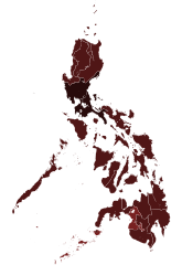
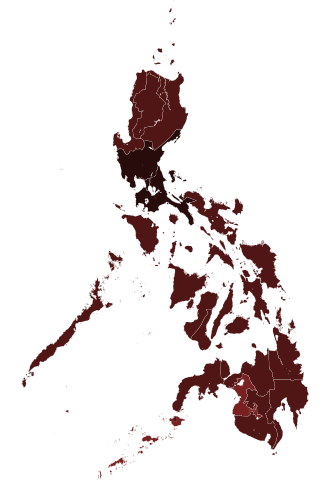
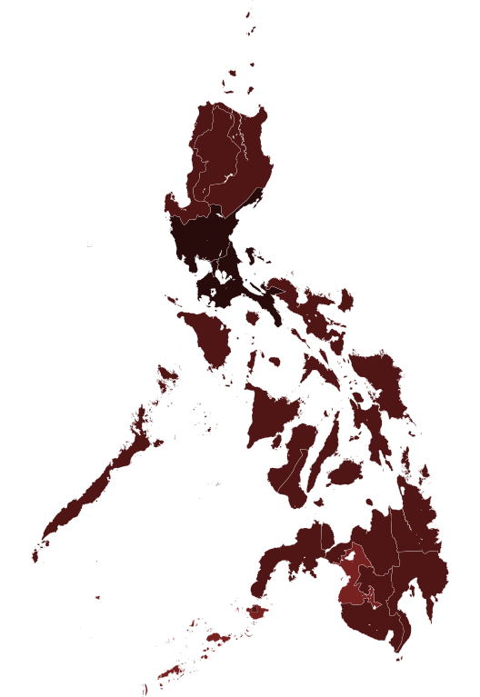
File:COVID-19 pandemic cases in the Philippines by region.svg

呢個「SVG」檔案嘅呢個「PNG」預覽嘅大細:412 × 599 像素。 第啲解像度:165 × 240 像素|330 × 480 像素|528 × 768 像素|704 × 1,024 像素|1,409 × 2,048 像素|4,200 × 6,105 像素。
原本檔案 (SVG檔案,表面大細: 4,200 × 6,105 像素,檔案大細:2.02 MB)
摘要
| 描述 |
|
||
| 日期 | (UTC) | ||
| 來源 |
This file was derived from: Philippines, administrative divisions - de - colored.svg:  |
||
| 作者 |
|
||
| Other versions |
|
||
| SVG genesis |

協議
I, the copyright holder of this work, hereby publish it under the following licenses:
呢個檔案用共享創意 姓名標示-非商業性-相同方式分享3.0 未本地化版本條款授權。
- 你可以:
- 去分享 – 複製、發佈同傳播呢個作品
- 再改 – 創作演繹作品
- 要遵照下面嘅條件:
- 署名 – 你一定要畀合適嘅表彰、畀返指向呢個授權條款嘅連結,同埋寫明有無改過嚟。你可以用任何合理方式去做,但唔可以用任何方式暗示授權人認可咗你或者你嘅使用方式。
- 相同方式分享 – 如果你用任何方式改過呢個作品,你必須要用返原本或者相似嘅條款發佈。

|
根據自由軟體基金會發佈嘅無固定段落、封面文字同封底文字GNU自由文件授權條款第1.2或打後嘅版本,你獲授權可以重製、散佈同埋修改爾份文件。授權條款嘅副本喺章節GNU自由文件授權條款。 |
你可以揀你想用嘅牌照。
Original upload log
This image is a derivative work of the following images:
- File:Philippines, administrative divisions - de - colored.svg licensed with Cc-by-sa-3.0, GFDL
- 2018-01-31T21:39:34Z Man77 1871x2468 (1801204 Bytes) Reverted to version as of 22:36, 16 August 2012 (UTC) NIR revoked
- 2016-03-25T22:45:38Z Man77 1871x2468 (1854996 Bytes) recolored some island
- 2016-03-25T22:40:52Z Man77 1871x2468 (1854960 Bytes) UPD NIR
- 2012-08-16T22:36:11Z TUBS 1871x2468 (1801204 Bytes) == {{int:filedesc}} == {{Information |Description={{de|Karte der politischen Gliederung von XY (siehe Dateiname)}} {{en|Map of administrative divisions of XY (see filename)}} |Source={{own}}
Uploaded with derivativeFX
檔案歷史
撳個日期/時間去睇響嗰個時間出現過嘅檔案。
| 日期/時間 | 縮圖 | 尺寸 | 用戶 | 註解 | |
|---|---|---|---|---|---|
| 現時 | 2021年6月6號 (日) 06:10 | | 4,200 × 6,105(2.02 MB) | HueMan1 | update |
| 2021年1月25號 (一) 01:57 |  | 4,200 × 6,105(2.02 MB) | HueMan1 | Update | |
| 2020年10月15號 (四) 23:09 |  | 4,200 × 6,105(2.02 MB) | Hariboneagle927 | Oct 15 | |
| 2020年8月26號 (三) 03:57 |  | 4,200 × 6,105(2.02 MB) | HueMan1 | Update | |
| 2020年8月13號 (四) 15:32 |  | 4,200 × 6,105(2.02 MB) | Hariboneagle927 | August 13 | |
| 2020年6月17號 (三) 08:13 |  | 4,200 × 6,105(2.02 MB) | Hariboneagle927 | update to June 16 as per the revamped DOH COVID-19 tracker https://www.doh.gov.ph/covid19tracker | |
| 2020年6月12號 (五) 09:50 |  | 4,200 × 6,105(2.02 MB) | Hariboneagle927 | update to June 10 http://geoportal.gov.ph/gpapps/covidapp | |
| 2020年6月4號 (四) 11:35 |  | 4,200 × 6,105(2.02 MB) | HueMan1 | Adjusted colours for 10000+ | |
| 2020年5月22號 (五) 23:29 |  | 4,200 × 6,105(2.02 MB) | Hariboneagle927 | May 22 | |
| 2020年5月10號 (日) 17:15 |  | 4,200 × 6,105(2.02 MB) | Hariboneagle927 | update May 10 |
檔案用途
全域檔案使用情況
下面嘅維基都用緊呢個檔案:
- ar.wikipedia.org嘅使用情況
- ca.wikipedia.org嘅使用情況
- eu.wikipedia.org嘅使用情況
- he.wikipedia.org嘅使用情況
- id.wikipedia.org嘅使用情況
- min.wikipedia.org嘅使用情況
- nl.wikipedia.org嘅使用情況
- pt.wikipedia.org嘅使用情況
- www.wikidata.org嘅使用情況