
File:Canal-coudoux91.jpg

預覽大細:800 × 600 像素。 第啲解像度:320 × 240 像素|640 × 480 像素|1,024 × 768 像素。
原本檔案 (1,024 × 768 像素,檔案大細:207 KB ,MIME類型:image/jpeg)
摘要
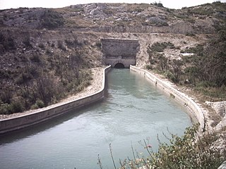
| 描述 | Un passage en souterrain au nord de Coudoux. Vue vers l'ouest depuis la route des Quatre Termes (vallon du Berratin). Tunnel d'environ 102 m de long ; à l'autre bout du tunnel sur la gauche se trouve une station de pompage. Le prochain tunnel dans cette direction est le souterrain de la Baume. |
| 日期 | |
| 來源 | 自己作品 |
| 作者 | Fr.Latreille |
| Camera location | | View this and other nearby images on: OpenStreetMap |
|---|
協議
| I, the copyright holder of this work, release this work into the public domain. This applies worldwide. In some countries this may not be legally possible; if so: I grant anyone the right to use this work for any purpose, without any conditions, unless such conditions are required by law. |
檔案歷史
撳個日期/時間去睇響嗰個時間出現過嘅檔案。
| 日期/時間 | 縮圖 | 尺寸 | 用戶 | 註解 | |
|---|---|---|---|---|---|
| 現時 | 2007年8月16號 (四) 12:39 | | 1,024 × 768(207 KB) | Fr.Latreille | {{Information |Description=Un passage en souterrain au nord de Coudoux |Source=personnel |Date=juin 2007 |Author=~~~ |Permission= |other_versions= }} Category:Canal de Marseille |
檔案用途
以下嘅1版用到呢個檔:
全域檔案使用情況
下面嘅維基都用緊呢個檔案:
- ca.wikipedia.org嘅使用情況
- ceb.wikipedia.org嘅使用情況
- ce.wikipedia.org嘅使用情況
- de.wikipedia.org嘅使用情況
- en.wikipedia.org嘅使用情況
- eo.wikipedia.org嘅使用情況
- es.wikipedia.org嘅使用情況
- eu.wikipedia.org嘅使用情況
- fr.wikipedia.org嘅使用情況
- hu.wikipedia.org嘅使用情況
- hy.wikipedia.org嘅使用情況
- ilo.wikipedia.org嘅使用情況
- it.wikipedia.org嘅使用情況
- la.wikipedia.org嘅使用情況
- lld.wikipedia.org嘅使用情況
- lmo.wikipedia.org嘅使用情況
- ms.wikipedia.org嘅使用情況
- oc.wikipedia.org嘅使用情況
- pam.wikipedia.org嘅使用情況
- ru.wikipedia.org嘅使用情況
- sk.wikipedia.org嘅使用情況
- sv.wikipedia.org嘅使用情況
- tt.wikipedia.org嘅使用情況
- uk.wikipedia.org嘅使用情況
- vec.wikipedia.org嘅使用情況
- vi.wikipedia.org嘅使用情況
- www.wikidata.org嘅使用情況
- zh-min-nan.wikipedia.org嘅使用情況
- zh.wikipedia.org嘅使用情況