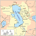
File:Caspianseamap.png

預覽大細:598 × 600 像素。 第啲解像度:239 × 240 像素|600 × 602 像素。
原本檔案 (600 × 602 像素,檔案大細:196 KB ,MIME類型:image/png)
檔案歷史
撳個日期/時間去睇響嗰個時間出現過嘅檔案。
| 日期/時間 | 縮圖 | 尺寸 | 用戶 | 註解 | |
|---|---|---|---|---|---|
| 現時 | 2018年8月20號 (一) 02:00 |  | 600 × 602(196 KB) | SteinsplitterBot | Bot: Image rotated by 180° |
| 2018年8月19號 (日) 10:01 |  | 600 × 602(196 KB) | SteinsplitterBot | Bot: Image rotated by 180° | |
| 2007年1月8號 (一) 20:40 |  | 600 × 602(199 KB) | Kmusser | ||
| 2007年1月8號 (一) 20:23 |  | 600 × 602(212 KB) | Kmusser | ||
| 2007年1月8號 (一) 20:14 |  | 600 × 602(212 KB) | Kmusser | This is a map of the Caspian Sea including a small locator map. The drainage basin of the Caspian Sea is in yellow. The map is based on USGS and Digital Chart of the World data. Note t |
檔案用途
全域檔案使用情況
下面嘅維基都用緊呢個檔案:
- af.wikipedia.org嘅使用情況
- am.wikipedia.org嘅使用情況
- an.wikipedia.org嘅使用情況
- ar.wikipedia.org嘅使用情況
- az.wikipedia.org嘅使用情況
- az.wiktionary.org嘅使用情況
- ba.wikipedia.org嘅使用情況
- be.wikipedia.org嘅使用情況
- br.wikipedia.org嘅使用情況
- ca.wikipedia.org嘅使用情況
- csb.wikipedia.org嘅使用情況
- cs.wikipedia.org嘅使用情況
- cv.wikipedia.org嘅使用情況
- de.wikipedia.org嘅使用情況
- en.wikipedia.org嘅使用情況
- en.wikivoyage.org嘅使用情況
- eo.wikipedia.org嘅使用情況
- es.wikipedia.org嘅使用情況
- eu.wikipedia.org嘅使用情況
- fa.wikipedia.org嘅使用情況
- fa.wikibooks.org嘅使用情況
- fi.wikipedia.org嘅使用情況
- fo.wikipedia.org嘅使用情況
- fr.wikipedia.org嘅使用情況
- gan.wikipedia.org嘅使用情況
- gd.wikipedia.org嘅使用情況
- gu.wikipedia.org嘅使用情況
睇呢個檔案嘅更多全域使用情況。


