
File:Curacao-CIA WFB Map.png
冇更高解像度嘅圖像。
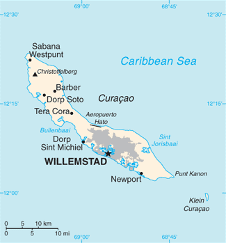
Curacao-CIA_WFB_Map.png (325 × 349 像素,檔案大細:11 KB ,MIME類型:image/png)
摘要
| 描述 |
English: Map of Curaçao from the 2010-10-22 revision of the World Factbook |
| 日期 | |
| 來源 | World Factbook website |
| 作者 | Directorate of Intelligence, CIA |
協議
This image is in the public domain because it contains materials that originally came from the United States Central Intelligence Agency's World Factbook.
|
 |
檔案歷史
撳個日期/時間去睇響嗰個時間出現過嘅檔案。
| 日期/時間 | 縮圖 | 尺寸 | 用戶 | 註解 | |
|---|---|---|---|---|---|
| 現時 | 2018年5月23號 (三) 11:13 | | 325 × 349(11 KB) | Ras67 | cropped, opt. |
| 2010年10月23號 (六) 11:21 |  | 330 × 353(13 KB) | Hoshie | {{Information |Description= Map of {{w|Curaçao}} from the 2010-10-22 revision of the World Factbook |Source= [https://www.cia.gov/library/publications/the-world-factbook/maps/maptemplate_cc.html World Factbook website] |Date= 2010-10-22 |Author= Director |
檔案用途
以下嘅1版用到呢個檔:
全域檔案使用情況
下面嘅維基都用緊呢個檔案:
- als.wikipedia.org嘅使用情況
- ast.wikipedia.org嘅使用情況
- ba.wikipedia.org嘅使用情況
- be-tarask.wikipedia.org嘅使用情況
- br.wikipedia.org嘅使用情況
- ca.wikipedia.org嘅使用情況
- cs.wikipedia.org嘅使用情況
- de.wikipedia.org嘅使用情況
- en.wikipedia.org嘅使用情況
- es.wikipedia.org嘅使用情況
- eu.wikipedia.org嘅使用情況
- fi.wikipedia.org嘅使用情況
- frr.wikipedia.org嘅使用情況
- ga.wikipedia.org嘅使用情況
- gl.wikipedia.org嘅使用情況
- he.wikipedia.org嘅使用情況
- hu.wikipedia.org嘅使用情況
- id.wikipedia.org嘅使用情況
- incubator.wikimedia.org嘅使用情況
- io.wikipedia.org嘅使用情況
- ja.wikipedia.org嘅使用情況
- ms.wikipedia.org嘅使用情況
- mt.wikipedia.org嘅使用情況
- nn.wikipedia.org嘅使用情況
- no.wikipedia.org嘅使用情況
- pl.wikipedia.org嘅使用情況
- pl.wiktionary.org嘅使用情況
- ru.wikipedia.org嘅使用情況
- sl.wikipedia.org嘅使用情況
- sw.wikipedia.org嘅使用情況
- ta.wikipedia.org嘅使用情況
- th.wikipedia.org嘅使用情況
- to.wikipedia.org嘅使用情況
- tt.wikipedia.org嘅使用情況
- uk.wikipedia.org嘅使用情況
- ur.wikipedia.org嘅使用情況
- vi.wikipedia.org嘅使用情況
睇呢個檔案嘅更多全域使用情況。