File:Ei-map.svg
閱讀設定

呢個「SVG」檔案嘅呢個「PNG」預覽嘅大細:517 × 599 像素。 第啲解像度:207 × 240 像素|414 × 480 像素|662 × 768 像素|883 × 1,024 像素|1,766 × 2,048 像素|652 × 756 像素。
原本檔案 (SVG檔案,表面大細: 652 × 756 像素,檔案大細:115 KB)
檔案歷史
撳個日期/時間去睇響嗰個時間出現過嘅檔案。
| 日期/時間 | 縮圖 | 尺寸 | 用戶 | 註解 | |
|---|---|---|---|---|---|
| 現時 | 2022年12月24號 (六) 15:16 |  | 652 × 756(115 KB) | Wikijahnn | File uploaded using svgtranslate tool (https://svgtranslate.toolforge.org/). Added translation for ca. |
| 2020年9月3號 (四) 19:34 |  | 652 × 756(110 KB) | Andrei Stroe | File uploaded using svgtranslate tool (https://svgtranslate.toolforge.org/). Added translation for ro. | |
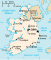
| 2006年7月24號 (一) 22:16 |  | 652 × 756(99 KB) | Wereon | Vector version of CIA WorldBook map of the Republic of Ireland. Mercator projection. Vector information is from the CIA World DataBank II, and hence in the public domain. |
檔案用途
以下嘅1版用到呢個檔:
全域檔案使用情況
下面嘅維基都用緊呢個檔案:
- af.wikipedia.org嘅使用情況
- af.wiktionary.org嘅使用情況
- ang.wikipedia.org嘅使用情況
- ar.wikipedia.org嘅使用情況
- arz.wikipedia.org嘅使用情況
- ast.wikipedia.org嘅使用情況
- be-tarask.wikipedia.org嘅使用情況
- be.wikipedia.org嘅使用情況
- bg.wikipedia.org嘅使用情況
- ca.wikipedia.org嘅使用情況
- ceb.wikipedia.org嘅使用情況
- cy.wikipedia.org嘅使用情況
- da.wikipedia.org嘅使用情況
- de.wikipedia.org嘅使用情況
- de.wiktionary.org嘅使用情況
- diq.wikipedia.org嘅使用情況
- dsb.wikipedia.org嘅使用情況
- dtp.wikipedia.org嘅使用情況
- el.wikipedia.org嘅使用情況
- en.wikipedia.org嘅使用情況
睇呢個檔案嘅更多全域使用情況。


