
File:Europe-Isle of Man.svg

呢個「SVG」檔案嘅呢個「PNG」預覽嘅大細:713 × 600 像素。 第啲解像度:285 × 240 像素|571 × 480 像素|913 × 768 像素|1,218 × 1,024 像素|2,435 × 2,048 像素|2,045 × 1,720 像素。
原本檔案 (SVG檔案,表面大細: 2,045 × 1,720 像素,檔案大細:2.24 MB)
摘要
| 描述 |
English:
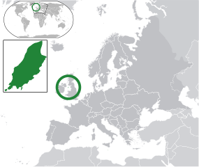
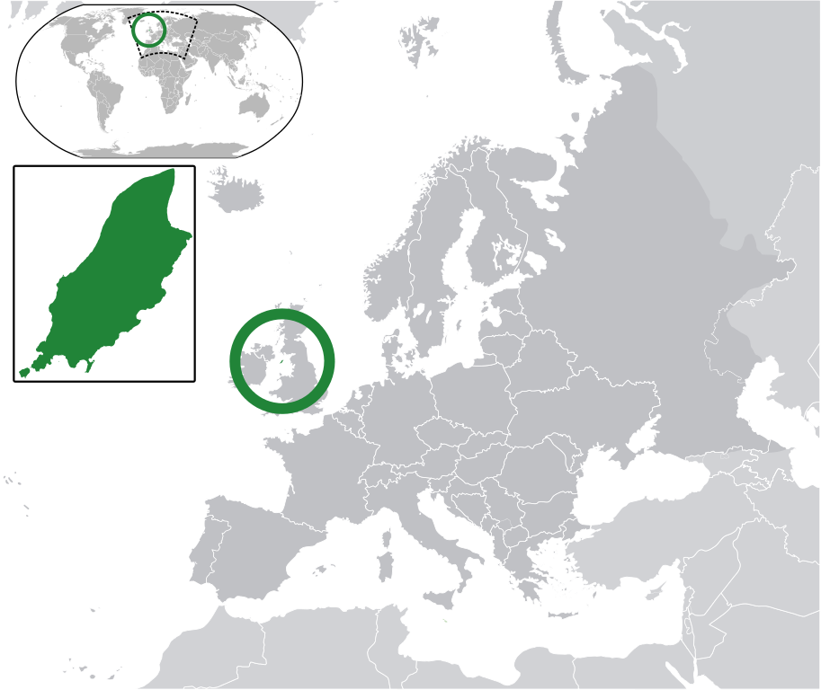
Map in English of the Isle of Man, with bounds of sheadings, towns, villages, districts and parishes. (Green) Isle of Man.
(Gray) Europe.
(Light-gray) The surrounding region.
The Full Map of the Isle of Man |
||
| 日期 | |||
| 來源 | Own work based on: IsleOfMan SheadingsAndParishes-en.svg | ||
| 作者 | Chipmunkdavis | ||
| 許可 (重用呢個檔案) |
呢個檔案用共享創意 姓名標示-非商業性-相同方式分享3.0 未本地化版本條款授權。
|
||
| SVG genesis |
|
Original upload log
This image is a derivative work of the following images:
- licensed with Cc-by-sa-3.0
- 2011-02-21T07:49:57Z Chipmunkdavis 2045x1720 (2394864 Bytes)
- IsleOfMan SheadingsAndParishes-en.svg licensed with Cc-by-sa-3.0,2.5,2.0,1.0, GFDL
- 2008-01-17T12:48:28Z Sémhur 1200x1100 (227618 Bytes) Update
- 2007-05-29T20:36:04Z Sémhur 0x0 (364350 Bytes) {{Information |Description=Map in English of the [[:en:Isle of Man|Isle of Man]], with bounds of sheadings, towns, villages, districts and parishes. |Source=Own work. Based on maps [[:Image:Isle of Man map-fr.svg]], [[:Image:
Uploaded with derivativeFX
檔案歷史
撳個日期/時間去睇響嗰個時間出現過嘅檔案。
| 日期/時間 | 縮圖 | 尺寸 | 用戶 | 註解 | |
|---|---|---|---|---|---|
| 現時 | 2011年3月2號 (三) 06:10 | | 2,045 × 1,720(2.24 MB) | Chipmunkdavis | Redid inset |
| 2011年3月2號 (三) 06:03 |  | 2,045 × 1,720(2.22 MB) | Chipmunkdavis | Without inset | |
| 2011年3月2號 (三) 06:01 |  | 2,045 × 1,720(2.22 MB) | Chipmunkdavis | One more try | |
| 2011年2月21號 (一) 09:03 |  | 2,045 × 1,720(2.22 MB) | Chipmunkdavis | Grouped inset | |
| 2011年2月21號 (一) 09:00 |  | 2,045 × 1,720(2.22 MB) | Chipmunkdavis | File not appearing properly, reuploading | |
| 2011年2月21號 (一) 08:06 |  | 2,045 × 1,720(2.22 MB) | Chipmunkdavis | {{Information |Description={{en|1={{Europe-SVG-en|Northern Cyprus}}}} {{en|1=The Full Map of Jersey}} Map in english of the Isle of Man, with bounds of sheadings, towns, villages, districts and parishes. |Source=*[[:File:Europe-Jersey. |
檔案用途
以下嘅1版用到呢個檔:
全域檔案使用情況
下面嘅維基都用緊呢個檔案:
- ace.wikipedia.org嘅使用情況
- an.wikipedia.org嘅使用情況
- ar.wikipedia.org嘅使用情況
- arz.wikipedia.org嘅使用情況
- ast.wikipedia.org嘅使用情況
- az.wikipedia.org嘅使用情況
- ba.wikipedia.org嘅使用情況
- bg.wikipedia.org嘅使用情況
- bh.wikipedia.org嘅使用情況
- bn.wikipedia.org嘅使用情況
- ca.wikipedia.org嘅使用情況
- cdo.wikipedia.org嘅使用情況
- cs.wikipedia.org嘅使用情況
- diq.wikipedia.org嘅使用情況
- en.wikipedia.org嘅使用情況
- eo.wikipedia.org嘅使用情況
- es.wikipedia.org嘅使用情況
- ext.wikipedia.org嘅使用情況
- fi.wiktionary.org嘅使用情況
- fr.wikipedia.org嘅使用情況
- ga.wikipedia.org嘅使用情況
- gl.wikipedia.org嘅使用情況
- hak.wikipedia.org嘅使用情況
- ha.wikipedia.org嘅使用情況
- he.wikipedia.org嘅使用情況
- ia.wikipedia.org嘅使用情況
- incubator.wikimedia.org嘅使用情況
- it.wikipedia.org嘅使用情況
- ja.wikipedia.org嘅使用情況
- kab.wikipedia.org嘅使用情況
- kk.wikipedia.org嘅使用情況
- km.wikipedia.org嘅使用情況
- la.wikipedia.org嘅使用情況
- lb.wikipedia.org嘅使用情況
- lij.wikipedia.org嘅使用情況
- lv.wikipedia.org嘅使用情況
- mk.wikipedia.org嘅使用情況
睇呢個檔案嘅更多全域使用情況。