
File:Fukushima City with a view of Fukushima Station.jpg

原本檔案 (3,957 × 2,630 像素,檔案大細:2.51 MB ,MIME類型:image/jpeg)
摘要
| 描述 |
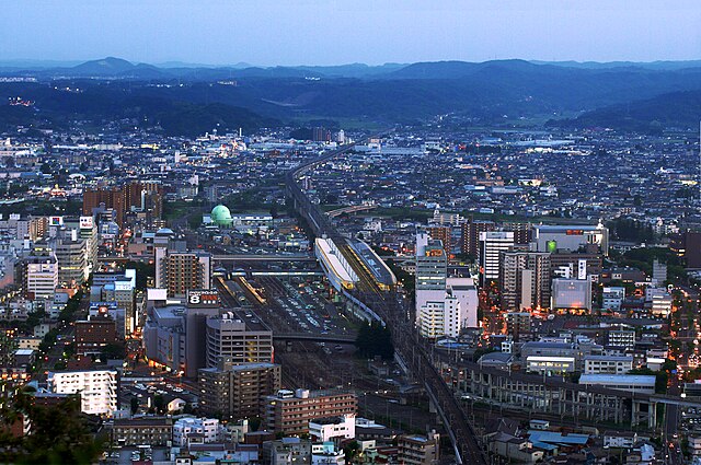
English: This is a view of Fukushima City, Fukushima Prefecture, Japan centered upon Fukushima Station.
Running from south (top of photo) to north (bottom of photo), the Tohoku Shinkansen connects Tokyo with the northeastern part of Honshu island, running all the way up to Aomori Prefecture. Fukushima Station's importance lies in that it's where the Yamagata Shinkansen (bottom right) splits off from the Tohoku Shinkansen and heads off on its own.
日本語: 福島県福島市の中心にある信夫山からの写真。福島駅は真ん中にある。 |
| 日期 | |
| 來源 | 自己作品 |
| 作者 | Purplepumpkins |
| Camera location | | View this and other nearby images on: OpenStreetMap |
|---|
協議
我,呢份作品嘅作者,決定用以下許可發佈呢件作品:
呢個檔案用共享創意 姓名標示-非商業性-相同方式分享3.0 未本地化版本條款授權。
- 你可以:
- 去分享 – 複製、發佈同傳播呢個作品
- 再改 – 創作演繹作品
- 要遵照下面嘅條件:
- 署名 – 你一定要畀合適嘅表彰、畀返指向呢個授權條款嘅連結,同埋寫明有無改過嚟。你可以用任何合理方式去做,但唔可以用任何方式暗示授權人認可咗你或者你嘅使用方式。
- 相同方式分享 – 如果你用任何方式改過呢個作品,你必須要用返原本或者相似嘅條款發佈。
檔案歷史
撳個日期/時間去睇響嗰個時間出現過嘅檔案。
| 日期/時間 | 縮圖 | 尺寸 | 用戶 | 註解 | |
|---|---|---|---|---|---|
| 現時 | 2011年6月23號 (四) 06:04 | | 3,957 × 2,630(2.51 MB) | Purplepumpkins |
檔案用途
以下嘅1版用到呢個檔:
全域檔案使用情況
下面嘅維基都用緊呢個檔案:
- af.wikipedia.org嘅使用情況
- ar.wikipedia.org嘅使用情況
- arz.wikipedia.org嘅使用情況
- azb.wikipedia.org嘅使用情況
- az.wikipedia.org嘅使用情況
- ca.wikipedia.org嘅使用情況
- ceb.wikipedia.org嘅使用情況
- ce.wikipedia.org嘅使用情況
- de.wikivoyage.org嘅使用情況
- el.wikipedia.org嘅使用情況
- en.wikipedia.org嘅使用情況
- en.wikivoyage.org嘅使用情況
- eo.wikipedia.org嘅使用情況
- es.wikipedia.org嘅使用情況
- fa.wikipedia.org嘅使用情況
- fi.wikipedia.org嘅使用情況
- fr.wikipedia.org嘅使用情況
- fr.wikivoyage.org嘅使用情況
- ga.wikipedia.org嘅使用情況
- gl.wikipedia.org嘅使用情況
- hr.wikipedia.org嘅使用情況
- hy.wikipedia.org嘅使用情況
- id.wikipedia.org嘅使用情況
- it.wikipedia.org嘅使用情況
- ja.wikipedia.org嘅使用情況
- ja.wikivoyage.org嘅使用情況
- kn.wikipedia.org嘅使用情況
- lt.wikipedia.org嘅使用情況
- lv.wikipedia.org嘅使用情況
- ml.wikipedia.org嘅使用情況
- my.wikipedia.org嘅使用情況
- no.wikipedia.org嘅使用情況
- pl.wikipedia.org嘅使用情況
- pl.wikivoyage.org嘅使用情況
- pt.wikipedia.org嘅使用情況
- pt.wiktionary.org嘅使用情況
- ru.wikipedia.org嘅使用情況
- sc.wikipedia.org嘅使用情況
- sh.wikipedia.org嘅使用情況
- simple.wikipedia.org嘅使用情況
- sq.wikipedia.org嘅使用情況
- sr.wikipedia.org嘅使用情況
睇呢個檔案嘅更多全域使用情況。