
File:Gulf of Taranto map.png

預覽大細:545 × 600 像素。 第啲解像度:218 × 240 像素|436 × 480 像素|698 × 768 像素|1,200 × 1,321 像素。
原本檔案 (1,200 × 1,321 像素,檔案大細:348 KB ,MIME類型:image/png)
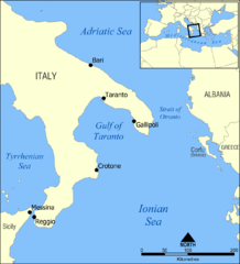
A map showing the location of the Gulf of Taranto in the Mediterranean sea, south of Italy.
Created by NormanEinstein, March 28, 2006.
我,呢份作品嘅作者,決定用以下許可發佈呢件作品:

|
根據自由軟體基金會發佈嘅無固定段落、封面文字同封底文字GNU自由文件授權條款第1.2或打後嘅版本,你獲授權可以重製、散佈同埋修改爾份文件。授權條款嘅副本喺章節GNU自由文件授權條款。 |
| 呢個檔案用共享創意 姓名標示-非商業性-相同方式分享3.0 未本地化版本條款授權。 | ||
| ||
| This licensing tag was added to this file as part of the GFDL licensing update. |
Other versions
- Croatian: File:Gulf of Taranto map hr.svg
檔案歷史
撳個日期/時間去睇響嗰個時間出現過嘅檔案。
| 日期/時間 | 縮圖 | 尺寸 | 用戶 | 註解 | |
|---|---|---|---|---|---|
| 現時 | 2009年6月3號 (三) 14:35 | | 1,200 × 1,321(348 KB) | Rhegion | added Reggio |
| 2006年3月28號 (二) 18:53 |  | 1,200 × 1,321(409 KB) | NormanEinstein | A map showing the location of the Gulf of Taranto in the Mediterranean sea, south of Italy. Created by NormanEinstein, March 28, 2006. {{GFDL-self}} |
檔案用途
以下嘅1版用到呢個檔:
全域檔案使用情況
下面嘅維基都用緊呢個檔案:
- ar.wikipedia.org嘅使用情況
- az.wikipedia.org嘅使用情況
- ba.wikipedia.org嘅使用情況
- be-tarask.wikipedia.org嘅使用情況
- be.wikipedia.org嘅使用情況
- br.wikipedia.org嘅使用情況
- bs.wikipedia.org嘅使用情況
- ckb.wikipedia.org嘅使用情況
- cs.wikipedia.org嘅使用情況
- da.wikipedia.org嘅使用情況
- de.wikipedia.org嘅使用情況
- de.wikibooks.org嘅使用情況
- el.wikipedia.org嘅使用情況
- en.wikipedia.org嘅使用情況
- Tegetthoff-class battleship
- SMS Szent István
- Gulf of Taranto
- SMS Prinz Eugen (1912)
- User:NormanEinstein/gallery
- Adriatic campaign of 1807–1814
- Wikipedia:Graphics Lab/Map workshop/Archive/Feb 2012
- SMS Saida
- Yugoslav torpedo boat T4
- Novara-class cruiser
- SMS Tegetthoff (1912)
- SMS Admiral Spaun
- SMS Orjen
- eo.wikipedia.org嘅使用情況
- es.wikipedia.org嘅使用情況
- eu.wikipedia.org嘅使用情況
- ext.wikipedia.org嘅使用情況
- fa.wikipedia.org嘅使用情況
- fi.wikipedia.org嘅使用情況
- fo.wikipedia.org嘅使用情況
- fr.wikipedia.org嘅使用情況
- gl.wikipedia.org嘅使用情況
睇呢個檔案嘅更多全域使用情況。