
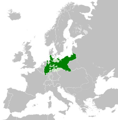
File:Kingdom of Prussia 1870.svg

呢個「SVG」檔案嘅呢個「PNG」預覽嘅大細:450 × 456 像素。 第啲解像度:237 × 240 像素|474 × 480 像素|758 × 768 像素|1,011 × 1,024 像素|2,021 × 2,048 像素。
原本檔案 (SVG檔案,表面大細: 450 × 456 像素,檔案大細:705 KB)
摘要
This W3C-unspecified vector image was created with Inkscape .


.svg)
.svg)
.svg)
.svg)
.svg)


.svg)
.svg)
.svg)


.png)
.png)


.svg)


.svg)

.svg)


.svg)
.svg)
.svg)
.svg)


.svg)
.png)


.svg)


.svg)
.svg)


.svg)


.svg)


.svg)
.svg)
.svg)
.svg)
.svg)
.svg)
.svg)
_cropped.svg)
.svg)
.svg)
.svg)
.svg)
.svg)
.svg)
.svg)
.svg)
.svg)
.svg)
.svg)
.svg)
.svg)
.svg)
.svg)
.svg)
.svg)
.svg)
.svg)
.svg)
.svg)
.svg)
.svg)
.svg)
.svg)
.svg)
.svg)
.svg)
.svg)
.svg)
.svg)
.svg)
.svg)
.svg)
.svg)
.svg)
.svg)
.svg)
.svg)
.svg)
.svg)
.svg)
.svg)
.svg)
.svg)
協議
This file is licensed under the Creative Commons Attribution-Share Alike 4.0 International license.
- 你可以:
- 去分享 – 複製、發佈同傳播呢個作品
- 再改 – 創作演繹作品
- 要遵照下面嘅條件:
- 署名 – 你一定要畀合適嘅表彰、畀返指向呢個授權條款嘅連結,同埋寫明有無改過嚟。你可以用任何合理方式去做,但唔可以用任何方式暗示授權人認可咗你或者你嘅使用方式。
- 相同方式分享 – 如果你用任何方式改過呢個作品,你必須要用返原本或者相似嘅條款發佈。
檔案歷史
撳個日期/時間去睇響嗰個時間出現過嘅檔案。
| 日期/時間 | 縮圖 | 尺寸 | 用戶 | 註解 | |
|---|---|---|---|---|---|
| 現時 | 2016年6月1號 (三) 02:54 | | 450 × 456(705 KB) | Alphathon | Various corrections to the states of the North German Confederation |
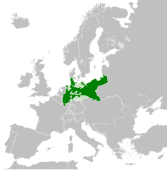
| 2016年5月31號 (二) 05:22 |  | 450 × 456(662 KB) | Alphathon | Minor corrections (Tarasp and post-1818 German Confederation border change) | |
| 2016年5月31號 (二) 02:40 |  | 450 × 456(662 KB) | Alphathon | == {{int:filedesc}} == {{Inkscape}} {{Information |Description={{en|A map of the en:Kingdom of Prussia within the North German Confederation and within Europe circa 1870 CE.}} |Source= {{Derived from|Blank_map_of_Europe.svg|display=50}} |Da... |
檔案用途
以下嘅1版用到呢個檔:
全域檔案使用情況
下面嘅維基都用緊呢個檔案:
- af.wiktionary.org嘅使用情況
- ar.wikipedia.org嘅使用情況
- bn.wikipedia.org嘅使用情況
- ckb.wikipedia.org嘅使用情況
- en.wikipedia.org嘅使用情況
- eo.wiktionary.org嘅使用情況
- es.wikipedia.org嘅使用情況
- es.wiktionary.org嘅使用情況
- eu.wikipedia.org嘅使用情況
- fa.wikipedia.org嘅使用情況
- fi.wikipedia.org嘅使用情況
- he.wikipedia.org嘅使用情況
- hu.wikipedia.org嘅使用情況
- is.wikipedia.org嘅使用情況
- it.wikipedia.org嘅使用情況
- li.wiktionary.org嘅使用情況
- lld.wikipedia.org嘅使用情況
- lt.wikipedia.org嘅使用情況
- mn.wikipedia.org嘅使用情況
- pl.wikipedia.org嘅使用情況
- pt.wikipedia.org嘅使用情況
- rue.wikipedia.org嘅使用情況
- ru.wikipedia.org嘅使用情況
- ru.wiktionary.org嘅使用情況
- sk.wikipedia.org嘅使用情況
- szl.wikipedia.org嘅使用情況
- tr.wikipedia.org嘅使用情況
- uk.wikipedia.org嘅使用情況
- uz.wikipedia.org嘅使用情況
- xmf.wikipedia.org嘅使用情況
- zh.wikipedia.org嘅使用情況