
File:Koh Samui Lipa Noi2.jpg

預覽大細:800 × 600 像素。 第啲解像度:320 × 240 像素|640 × 480 像素|1,024 × 768 像素。
原本檔案 (1,024 × 768 像素,檔案大細:222 KB ,MIME類型:image/jpeg)
摘要
| 描述 |
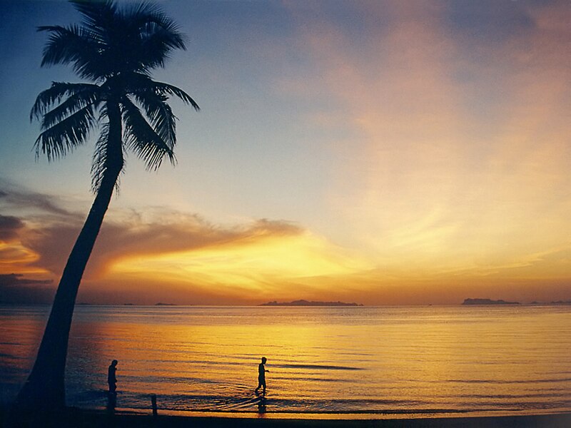
Koh Samui (Surat Thani, Thailand)
|
| 日期 | 2004年3月 |
| 來源 | picture taken by Manfred Werner |
| 作者 | Manfred Werner |
| 許可 (重用呢個檔案) |
Manfred Werner released it under GFDL |
| Camera location | | View this and other nearby images on: OpenStreetMap |
|---|

|
根據自由軟體基金會發佈嘅無固定段落、封面文字同封底文字GNU自由文件授權條款第1.2或打後嘅版本,你獲授權可以重製、散佈同埋修改爾份文件。授權條款嘅副本喺章節GNU自由文件授權條款。 |
| 呢個檔案用共享創意 姓名標示-非商業性-相同方式分享3.0 未本地化版本條款授權。 | ||
| ||
| This licensing tag was added to this file as part of the GFDL licensing update. |
|
This image was selected as picture of the day on Wikimedia Commons for 17 November 2004. It was captioned as follows: English: Lipa Noi Beach on Ko Samui, Thailand, shortly after sunset. The islands of the Ang Thong Marine National Park (Mu Koh Angthong) are visible at the horizon. Other languages:
Brezhoneg : Traezhenn Lipa Noi war enez Ko Samui e Thailandia just goude ar c'huzh-heol. Gwelet a reer er pelloù inizi eus Park Mor Broadel Ang Thong (Mu Koh Angthong). Dansk: Lipa Noi-stranden på Ko Samui i Thailand lige efter solnedgang. Øerne til Ang Thong Marine National Park (Mu Koh Angthong) er synlige i horisonten. Deutsch: Der Strand Lipa Noi in Ko Samui, Thailand, kurz nach dem Sonnenuntergang. Am Horizont sieht man die Inseln des Ang Thong Meeres National Park (Mu Koh Angthong). English: Lipa Noi Beach on Ko Samui, Thailand, shortly after sunset. The islands of the Ang Thong Marine National Park (Mu Koh Angthong) are visible at the horizon. Español: Playas de Lipa Noi, en Ko Samui, apenas puesto el sol. En el horizonte se pueden observar las islas del Parque Nacional Marítimo Ang Thong Esperanto: La Lipa Noi Plaĝo en Ko Samui, Tajlando nelonge post sunsubiro. La insuloj de la Ang Thong Nacia Parko (Mu Koh Angthong) estas videbla en la horizonto Français : La plage Lipa Noi à Ko Samui en Thaïlande juste après le coucher du soleil. À l'horizon, apparaisent des îles du Parc maritime national Ang Thong (Mu Koh Angthong). Norsk nynorsk: Lipa Noi-stranda på Ko Samui i Thailand rett etter solnedgang. Øyane til Ang Thong Marine National Park (Mu Koh Angthong) er synlege i horisonten. Polski: Plaża Lipa Noi na Ko Samui, Tajlandia, krótko po zachodzie słońca. Na horyzoncie widać morski park narodowy Ang Thong (Mu Koh Angthong). |
檔案歷史
撳個日期/時間去睇響嗰個時間出現過嘅檔案。
| 日期/時間 | 縮圖 | 尺寸 | 用戶 | 註解 | |
|---|---|---|---|---|---|
| 現時 | 2007年8月8號 (三) 15:21 | | 1,024 × 768(222 KB) | Smial | denoised |
| 2005年9月7號 (三) 15:36 |  | 1,024 × 768(240 KB) | Tsui | ||
| 2004年11月11號 (四) 18:49 |  | 800 × 600(91 KB) | Ahoerstemeier |
檔案用途
全域檔案使用情況
下面嘅維基都用緊呢個檔案:
- ar.wikipedia.org嘅使用情況
- arz.wikipedia.org嘅使用情況
- az.wikipedia.org嘅使用情況
- ba.wikipedia.org嘅使用情況
- be.wikipedia.org嘅使用情況
- bg.wikipedia.org嘅使用情況
- bn.wikivoyage.org嘅使用情況
- ca.wikipedia.org嘅使用情況
- cy.wikipedia.org嘅使用情況
- da.wikipedia.org嘅使用情況
- de.wikipedia.org嘅使用情況
- Surat Thani (Provinz)
- Ko Samui
- Portal:Tourismus und Sehenswürdigkeiten
- Benutzer:BLueFiSH.as/WLB
- Benutzer:Meph666/Galerie
- Portal:Thailand
- Wikipedia:Kandidaten für exzellente Bilder/Archiv2005/9
- Portal:Thailand/Listen Sehenswürdigkeiten
- Benutzer:Gedeon
- Benutzer:Cmoder/Gute Fotos
- Benutzer:Badehaubendealer/Zwei
- Benutzer:Gedeon/Bilder
- Benutzer Diskussion:Baldhur/Archiv/2005
- Wikipedia:Kandidaten für exzellente Bilder/Archiv2007/12
- Benutzer:KohSamui
- de.wikibooks.org嘅使用情況
- de.wikivoyage.org嘅使用情況
- en.wikipedia.org嘅使用情況
- Ko Samui
- Wikipedia:Picture of the day/December 2004
- Wikipedia:Featured picture candidates/Koh Samui Lipa Noi
- Wikipedia:POTD/December 4, 2004
- Wikipedia:Picture of the day/December 4, 2004
- Wikipedia:Featured picture candidates/December-2004
- User:Cyde/Featured pictures
- Wikipedia:Picture of the day/February 2006
- Wikipedia:POTD row/February 17, 2006
- Wikipedia:POTD/February 17, 2006
- Wikipedia:Picture of the day/February 17, 2006
- Wikipedia:POTD column/February 17, 2006
- Template talk:Holiday
- Portal:Geography/Featured picture/2006, week 29
- User:Viva La Vie Boheme!/gallery
- Portal:Geography/Featured picture/2006, week 30
- Portal:Geography/Featured picture/2006, week 31
睇呢個檔案嘅更多全域使用情況。