
File:Kosovo location map.svg

呢個「SVG」檔案嘅呢個「PNG」預覽嘅大細:529 × 599 像素。 第啲解像度:212 × 240 像素|424 × 480 像素|678 × 768 像素|904 × 1,024 像素|1,808 × 2,048 像素|1,015 × 1,150 像素。
原本檔案 (SVG檔案,表面大細: 1,015 × 1,150 像素,檔案大細:149 KB)

|
The boundaries on this map show the de facto situation. This is just one of several different views on the subject (see COM:NPOV). |
摘要
| 描述 |
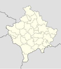
Deutsch: Positionskarte des Kosovo
Quadratische Plattkarte, N-S-Streckung 140 %. Geographische Begrenzung der Karte:
English: Location map of Kosovo
Equirectangular projection, N/S stretching 140 %. Geographic limits of the map:
|
| 日期 | 01-08-2008 |
| 來源 | own work, using United States National Imagery and Mapping Agency data |
| 作者 | NordNordWest |

|
This map has been made or improved in the German Kartenwerkstatt (Map Lab). You can propose maps to improve as well.
|
協議
I, the copyright holder of this work, hereby publish it under the following licenses:

|
根據自由軟體基金會發佈嘅無固定段落、封面文字同封底文字GNU自由文件授權條款第1.2或打後嘅版本,你獲授權可以重製、散佈同埋修改爾份文件。授權條款嘅副本喺章節GNU自由文件授權條款。 |
呢個檔案用共享創意 姓名標示-非商業性-相同方式分享3.0 未本地化版本條款授權。
- 你可以:
- 去分享 – 複製、發佈同傳播呢個作品
- 再改 – 創作演繹作品
- 要遵照下面嘅條件:
- 署名 – 你一定要畀合適嘅表彰、畀返指向呢個授權條款嘅連結,同埋寫明有無改過嚟。你可以用任何合理方式去做,但唔可以用任何方式暗示授權人認可咗你或者你嘅使用方式。
- 相同方式分享 – 如果你用任何方式改過呢個作品,你必須要用返原本或者相似嘅條款發佈。
你可以揀你想用嘅牌照。
檔案歷史
撳個日期/時間去睇響嗰個時間出現過嘅檔案。
| 日期/時間 | 縮圖 | 尺寸 | 用戶 | 註解 | |
|---|---|---|---|---|---|
| 現時 | 2016年12月15號 (四) 16:53 | | 1,015 × 1,150(149 KB) | NordNordWest | Reverted to version as of 10:16, 13 December 2016 (UTC); yeah, strange, try official maps; and now stop changing this map without a discussion _before_ |
| 2016年12月15號 (四) 14:08 |  | 1,015 × 1,150(103 KB) | AceDouble | Reverted to version as of 22:04, 12 December 2016 (UTC) Strange boundaries!? that's a funny one. Check it here> http://www.balgoc.org.tr/harita/kosova.jpg | |
| 2016年12月13號 (二) 10:16 |  | 1,015 × 1,150(149 KB) | NordNordWest | Reverted to version as of 13:03, 23 November 2009 (UTC); no need for different colours, strange boundaries | |
| 2016年12月12號 (一) 22:04 |  | 1,015 × 1,150(103 KB) | AceDouble | update | |
| 2009年11月23號 (一) 13:03 |  | 1,015 × 1,150(149 KB) | NordNordWest | update | |
| 2009年5月6號 (三) 18:49 |  | 1,016 × 1,150(198 KB) | NordNordWest | more detailed | |
| 2008年8月29號 (五) 08:04 |  | 1,016 × 1,150(78 KB) | NordNordWest | ||
| 2008年8月1號 (五) 17:41 |  | 339 × 383(77 KB) | NordNordWest | {{Information |Description= {{de|Positionskarte des Kosovo}} Quadratische Plattkarte, N-S-Streckung 140 %. Geographische Begrenzung der Karte: * N: 43.4° N * S: 41.7° N * W: 19.8° O * O: 21.9° O {{en|Location map of [[:en:Kosovo|Kosovo] |
檔案用途
無嘢連來呢份檔案。
全域檔案使用情況
下面嘅維基都用緊呢個檔案:
- de.wikipedia.org嘅使用情況
- eo.wikipedia.org嘅使用情況
- es.wikipedia.org嘅使用情況
- fr.wikipedia.org嘅使用情況
- mt.wikipedia.org嘅使用情況
- pl.wikipedia.org嘅使用情況
- ru.wikipedia.org嘅使用情況
- sv.wikipedia.org嘅使用情況
- uk.wikipedia.org嘅使用情況