
File:Kuala Lumpur locator map.svg

呢個「SVG」檔案嘅呢個「PNG」預覽嘅大細:428 × 599 像素。 第啲解像度:171 × 240 像素|343 × 480 像素|548 × 768 像素|731 × 1,024 像素|1,463 × 2,048 像素|500 × 700 像素。
原本檔案 (SVG檔案,表面大細: 500 × 700 像素,檔案大細:306 KB)
摘要
| 描述 |
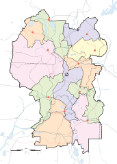
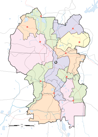
English: Map of w:Kuala Lumpur divided according to constituencies with highways (black) and major roads (red). City centre is marked by a Star Button and constituency towns marked by Red Buttons. Mukims (communes) are marked with dotted lines. |
||
| 日期 | |||
| 來源 |
Own work by uploader for w:Wikipedia:WikiProject Malaysia/Cartography New boundaries were from SPR Malaysia and Tindak Malaysia (2018) |
||
| 作者 |
|
||
| Other versions | File:Kuala Lumpur subdistrict locator map.svg |
協議
我,呢份作品嘅作者,決定用以下許可發佈呢件作品:
This file is licensed under the Creative Commons Attribution-Share Alike 4.0 International license.
- 你可以:
- 去分享 – 複製、發佈同傳播呢個作品
- 再改 – 創作演繹作品
- 要遵照下面嘅條件:
- 署名 – 你一定要畀合適嘅表彰、畀返指向呢個授權條款嘅連結,同埋寫明有無改過嚟。你可以用任何合理方式去做,但唔可以用任何方式暗示授權人認可咗你或者你嘅使用方式。
- 相同方式分享 – 如果你用任何方式改過呢個作品,你必須要用返原本或者相似嘅條款發佈。
檔案歷史
撳個日期/時間去睇響嗰個時間出現過嘅檔案。
| 日期/時間 | 縮圖 | 尺寸 | 用戶 | 註解 | |
|---|---|---|---|---|---|
| 現時 | 2020年4月29號 (三) 19:50 | | 500 × 700(306 KB) | *angys* | add mukim boundaries |
| 2020年4月29號 (三) 19:18 |  | 500 × 700(293 KB) | *angys* | Refined boundary, many thanks to Tindak Malaysia | |
| 2018年9月10號 (一) 18:00 |  | 500 × 700(379 KB) | *angys* | new seat boundary from File:Selangor WPKL PRU14.svg | |
| 2009年6月22號 (一) 11:56 |  | 500 × 700(307 KB) | Mdzafri | {{Information |Description={{en|1=Map of w:Kuala Lumpur divided according to constituencies with highways (black) and major roads (red). City centre is marked by a Star Button and constituency towns marked by Red Buttons.}} |Source=Own work by uploade |
檔案用途
全域檔案使用情況
下面嘅維基都用緊呢個檔案:
- ar.wikipedia.org嘅使用情況
- bjn.wikipedia.org嘅使用情況
- ceb.wikipedia.org嘅使用情況
- en.wikipedia.org嘅使用情況
- Bangsar
- Taman Tun Dr Ismail
- RMAF Kuala Lumpur Air Base
- Wangsa Maju
- Islamic Arts Museum Malaysia
- User:Mdzafri
- Module:Location map/data/Malaysia Kuala Lumpur/doc
- Abdul Rahman Auf Mosque
- Kuala Lumpur Hospital
- Wikipedia:Meetup/Kuala Lumpur
- The Boulevard Hotel Kuala Lumpur
- Module:Location map/data/Malaysia Kuala Lumpur
- Wikipedia:Graphics Lab/Map workshop/Archive/Jun 2018
- 2019 Malaysia M3 League
- 2020 Malaysia M3 League
- Wikipedia:Graphics Lab/Map workshop/Archive/Feb 2020
- fa.wikipedia.org嘅使用情況
- fr.wikipedia.org嘅使用情況
- he.wikipedia.org嘅使用情況
- id.wikipedia.org嘅使用情況
- jv.wikipedia.org嘅使用情況
- kn.wikipedia.org嘅使用情況
- ms.wikipedia.org嘅使用情況
- mt.wikipedia.org嘅使用情況
- pl.wikipedia.org嘅使用情況
睇呢個檔案嘅更多全域使用情況。