
File:Map-antarctica-ross-ice-shelf-red-x.png
冇更高解像度嘅圖像。
Map-antarctica-ross-ice-shelf-red-x.png (316 × 313 像素,檔案大細:26 KB ,MIME類型:image/png)
| 描述 |
|
| 日期 | (UTC) |
| 來源 | |
| 作者 |
|
| Other versions | Derivative works of this file: Antarctica map indicating Antarctic Peninsula.JPG |
| This is a retouched picture, which means that it has been digitally altered from its original version. Modifications: Cropped, put in red X on the Ross ice shelf.. The original can be viewed here: Antarctica Map.png:
|
This image is in the public domain because it contains materials that originally came from the United States Central Intelligence Agency's World Factbook.
|
 |
Original upload log
This image is a derivative work of the following images:
- File:Antarctica_Map.png licensed with PD-USGov-CIA-WF
- 2004-12-15T23:16:35Z Mschlindwein 502x617 (53433 Bytes)
Uploaded with derivativeFX
檔案歷史
撳個日期/時間去睇響嗰個時間出現過嘅檔案。
| 日期/時間 | 縮圖 | 尺寸 | 用戶 | 註解 | |
|---|---|---|---|---|---|
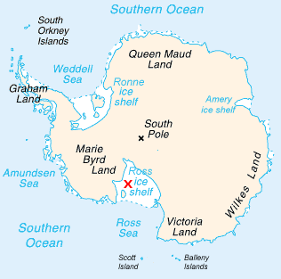
| 現時 | 2009年2月16號 (一) 17:22 | | 316 × 313(26 KB) | Jeandré du Toit | {{Information |Description=*Map of Antarctica with a red X on the Ross ice shelf. |Source=*File:Antarctica_Map.png |Date=2009-02-16 17:20 (UTC) |Author=*File:Antarctica_Map.png *derivative work: ~~~ |Permission=see below |other_versions= }} { |
檔案用途
無嘢連來呢份檔案。
全域檔案使用情況
下面嘅維基都用緊呢個檔案:
- en.wikipedia.org嘅使用情況
- fi.wikipedia.org嘅使用情況
- gv.wikipedia.org嘅使用情況
- id.wikipedia.org嘅使用情況
- ja.wikipedia.org嘅使用情況
- mk.wikipedia.org嘅使用情況
- ms.wikipedia.org嘅使用情況
- pt.wikipedia.org嘅使用情況
- zh.wikipedia.org嘅使用情況