
File:Map of Ontario GOLDEN HORSESHOE.svg

呢個「SVG」檔案嘅呢個「PNG」預覽嘅大細:340 × 330 像素。 第啲解像度:247 × 240 像素|495 × 480 像素|791 × 768 像素|1,055 × 1,024 像素|2,110 × 2,048 像素。
原本檔案 (SVG檔案,表面大細: 340 × 330 像素,檔案大細:84 KB)
摘要
This W3C-unspecified vector image was created with Inkscape .
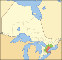
| 描述 | A map showing which census divisions make up the en:Golden Horseshoe (red) and the Greater Golden Horseshoe (Green) |
| 日期 | |
| 來源 | Crop and trace of Image:Canada (geolocalisation).svg; trace of Image:Ontario subdivisions.PNG. |
| 作者 | Vidioman |
| Other versions | en:Image:Goldhorse.PNG |
.svg)
協議
| I, the copyright holder of this work, release this work into the public domain. This applies worldwide. In some countries this may not be legally possible; if so: I grant anyone the right to use this work for any purpose, without any conditions, unless such conditions are required by law. |
檔案歷史
撳個日期/時間去睇響嗰個時間出現過嘅檔案。
| 日期/時間 | 縮圖 | 尺寸 | 用戶 | 註解 | |
|---|---|---|---|---|---|
| 現時 | 2007年10月15號 (一) 12:08 | | 340 × 330(84 KB) | Vidioman | {{Created with Inkscape}} {{Information |Description=A map showing which census divisions make up the Golden Horseshoe (red) and the Greater Golden Horseshoe (Green) |Source=Crop and trace of Image:Canada (geolocalisation).svg; trace of [http://en.wi |
.svg)
檔案用途
以下嘅1版用到呢個檔:
全域檔案使用情況
下面嘅維基都用緊呢個檔案:
- ca.wikipedia.org嘅使用情況
- ckb.wikipedia.org嘅使用情況
- cs.wikipedia.org嘅使用情況
- de.wikipedia.org嘅使用情況
- el.wikipedia.org嘅使用情況
- en.wikipedia.org嘅使用情況
- Golden Horseshoe
- Aldershot, Burlington
- Ridgeville, Ontario
- Queensville, Ontario
- Scugog River
- Lincoln County, Ontario
- Greater Toronto Bioregion
- German Mills Creek
- King Creek, Ontario
- Temperanceville, Ontario
- Snowball, Ontario
- Strange, Ontario
- Lloydtown, Ontario
- Seaton, Ontario
- Mount Pleasant, Brampton
- Mountsberg Conservation Area
- Nassagaweya Township, Ontario
- Merritton
- Newtonville, Ontario
- Claireville, Brampton
- Gore District, Upper Canada
- Holland River
- Lake Gibson (Ontario)
- Mount Nemo Conservation Area
- Hilton Falls Conservation Area
- Template:GoldenHorseshoe-geo-stub
- Short Hills Provincial Park
- Vrooman's Point
- Millgrove, Ontario
- Spencer Smith Park
- Willoughby Township, Ontario
- Heart Lake (Ontario)
- Edgeley, Vaughan
- Purpleville, Ontario
- Snake Island (Lake Simcoe)
- Teston, Vaughan
- Chinguacousy
- Template:User Golden Horseshoe
- Economy of Hamilton, Ontario
- User:The Canadian Roadgeek/All Userboxes
- Coyle Creek
- User:Jessejj89
- Fruitland, Ontario
- Myrtle, Ontario
- Myrtle Station, Ontario
睇呢個檔案嘅更多全域使用情況。