
File:Nagorno-Karabakh war map (2020).svg

呢個「SVG」檔案嘅呢個「PNG」預覽嘅大細:667 × 462 像素。 第啲解像度:320 × 222 像素|640 × 443 像素|1,024 × 709 像素|1,280 × 887 像素|2,560 × 1,773 像素。
原本檔案 (SVG檔案,表面大細: 667 × 462 像素,檔案大細:972 KB)
.svg?uselang=yue)
摘要
| 描述 |
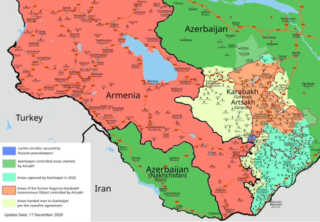
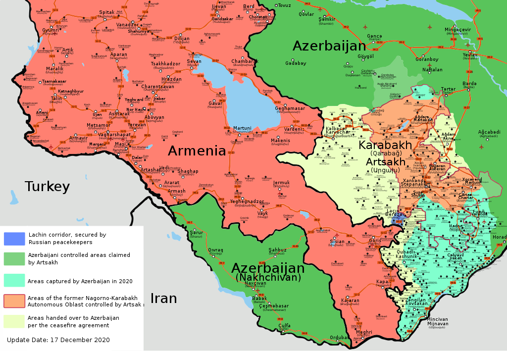
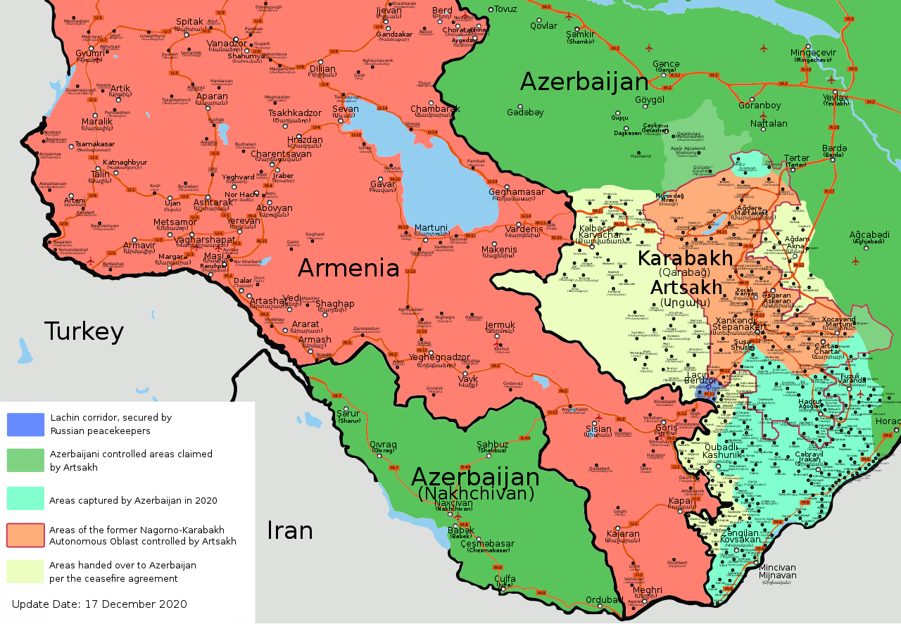
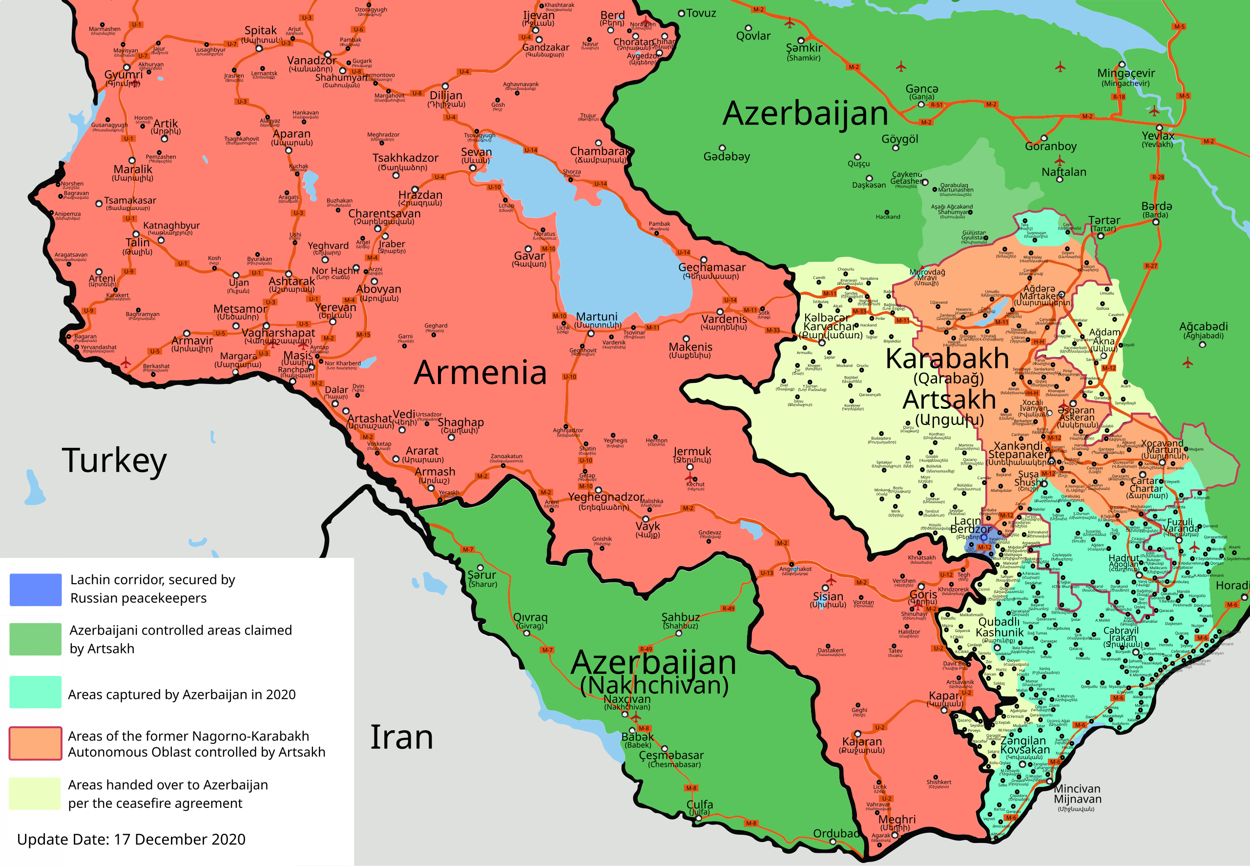
Azərbaycanca: Qarabağ döyüşləri (sentyabr, 2020) xəritəsi Deutsch: Karte des Krieges um Bergkarabach 2020 English: 2020 Nagorno-Karabakh conflict map Español: 2020 Mapa del conflicto de Nagorno-Karabaj Interlingue: Carte del conflicte de Nagorno-Karabakh de 2020 Türkçe: 2020 Dağlık Karabağ çatışmaları haritası Ελληνικά: Χάρτης της σύγκρουσης στο Ναγκόρνο-Καραμπάχ το 2020 فارسی : نقشه درگیری های قره باغ ۲۰۲۰ |
| 日期 | 2020-10-03, revised and updated in December 2020 |
| 來源 | 自己作品 |
| 作者 | Emreculha |
| Other versions |
Derivative works of this file: |
| SVG genesis |

|
This file may be updated to reflect new information. If you wish to use a specific version of the file without new updates being mirrored, please upload the required version as a separate file. |
協議
我,呢份作品嘅作者,決定用以下許可發佈呢件作品:
This file is licensed under the Creative Commons Attribution-Share Alike 4.0 International license.
- 你可以:
- 去分享 – 複製、發佈同傳播呢個作品
- 再改 – 創作演繹作品
- 要遵照下面嘅條件:
- 署名 – 你一定要畀合適嘅表彰、畀返指向呢個授權條款嘅連結,同埋寫明有無改過嚟。你可以用任何合理方式去做,但唔可以用任何方式暗示授權人認可咗你或者你嘅使用方式。
- 相同方式分享 – 如果你用任何方式改過呢個作品,你必須要用返原本或者相似嘅條款發佈。
檔案歷史
撳個日期/時間去睇響嗰個時間出現過嘅檔案。
.svg&dir=prev)
.svg&offset=20201129105030)
.svg&offset=&limit=20)
.svg&offset=&limit=50)
.svg&offset=&limit=100)
.svg&offset=&limit=250)
.svg&offset=&limit=500)
| 日期/時間 | 縮圖 | 尺寸 | 用戶 | 註解 | |
|---|---|---|---|---|---|
| 現時 | 2021年2月3號 (三) 21:31 | | 667 × 462(972 KB) | GrandEscogriffe | File uploaded using svgtranslate tool (https://svgtranslate.toolforge.org/). Added translation for fr. |
| 2020年12月27號 (日) 14:19 |  | 667 × 462(935 KB) | AntonSamuel | Minor fixes | |
| 2020年12月21號 (一) 14:28 |  | 667 × 462(934 KB) | AntonSamuel | Updates, fixes | |
| 2020年12月17號 (四) 18:57 |  | 667 × 462(897 KB) | Emreculha | Çaylaqqala and Köhne Tağlar cede to Azerbaijan (Source BBC MAP: https://www.bbc.com/azeri/azerbaijan-55253513), edits | |
| 2020年12月13號 (日) 14:23 |  | 668 × 462(971 KB) | Robins7 | File uploaded using svgtranslate tool (https://svgtranslate.toolforge.org/). Added translation for cs. | |
| 2020年12月8號 (二) 09:38 |  | 668 × 462(939 KB) | AntonSamuel | Color changes per talk | |
| 2020年12月6號 (日) 22:14 |  | 668 × 462(937 KB) | AntonSamuel | Adding Lachin corridor under Russian peacekeeper control. Fixing some incorrect border markings, Correction: Khtsaberd/Çaylaqqala, Hin Tagher/Köhnə Tağlar & Katarovank under Artsakh control: https://www.civilnet.am/news/2020/12/03/A-Piece-of-Hadrut-Remains-Armenian/411299, https://news.am/eng/news/614981.html, https://caucasus.liveuamap.com/en/2020/27-november-civilnet-anzhelika-zakaryan-says-that-armenians, https://caucasus.liveuamap.com/en/2020/27-november-armenians-still-hold-aylaqqalakhts... | |
| 2020年11月30號 (一) 12:14 |  | 668 × 462(897 KB) | Mastersun25 | Reverted to version as of 10:50, 29 November 2020 (UTC) Please make your edits to the latest version of the map | |
| 2020年11月29號 (日) 17:16 |  | 668 × 462(1,008 KB) | Santasa99 | Wording which corresponds to wording used in article | |
| 2020年11月29號 (日) 10:50 |  | 668 × 462(897 KB) | Emreculha | Minor edits *The Road of Shusha (M-12 it was deleted) *Yuxarı Veyselli |
檔案用途
以下嘅1版用到呢個檔:
全域檔案使用情況
下面嘅維基都用緊呢個檔案:
- af.wikipedia.org嘅使用情況
- an.wikipedia.org嘅使用情況
- ar.wikipedia.org嘅使用情況
- azb.wikipedia.org嘅使用情況
- be-tarask.wikipedia.org嘅使用情況
- be.wikipedia.org嘅使用情況
- bg.wikipedia.org嘅使用情況
- bn.wikipedia.org嘅使用情況
- ckb.wikipedia.org嘅使用情況
- cs.wikipedia.org嘅使用情況
- cs.wikinews.org嘅使用情況
- cv.wikipedia.org嘅使用情況
- da.wikipedia.org嘅使用情況
- de.wikipedia.org嘅使用情況
- en.wikipedia.org嘅使用情況
- User:PubSyr/sandbox
- Talk:Second Nagorno-Karabakh War/Archive 4
- Module:Location map/data/2020 Nagorno-Karabakh conflict map
- Module:Location map/data/2020 Nagorno-Karabakh conflict map/doc
- Wikipedia:Administrators' noticeboard/Archive326
- Wikipedia:Dispute resolution noticeboard/Archive 201
- User:Edisonabcd/sandbox
- eo.wikinews.org嘅使用情況
- es.wikipedia.org嘅使用情況
- et.wikipedia.org嘅使用情況
- eu.wikipedia.org嘅使用情況
- fa.wikipedia.org嘅使用情況
- fi.wikipedia.org嘅使用情況
- fr.wikipedia.org嘅使用情況
- gl.wikipedia.org嘅使用情況
- haw.wikipedia.org嘅使用情況
- he.wikipedia.org嘅使用情況
- hy.wikipedia.org嘅使用情況
- hyw.wikipedia.org嘅使用情況
- id.wikipedia.org嘅使用情況
- it.wikipedia.org嘅使用情況
睇呢個檔案嘅更多全域使用情況。
.svg)
.svg)