
File:Nordic Bronze Age.png

預覽大細:577 × 600 像素。 第啲解像度:231 × 240 像素|462 × 480 像素|657 × 683 像素。
原本檔案 (657 × 683 像素,檔案大細:31 KB ,MIME類型:image/png)

|
This historical map image could be recreated using vector graphics as an SVG file. This has several advantages; see Commons:Media for cleanup for more information. If an SVG form of this image is already available, please upload it. After uploading an SVG, replace this template with {{vector version available|new image name.svg}}.
|
摘要
| 描述 |
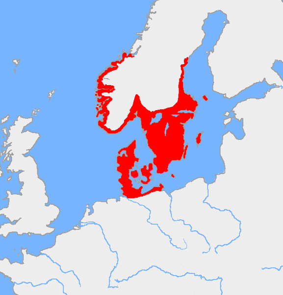
English: The Nordic Bronze Age culture, ca 1200 BC. |
| 來源 | Own work based on: Europe plain rivers.png and the Harper Atlas of World History (ed. Vidal-Naquet) in Swedish translation: Atlas över mänsklighetens historia. |
| 作者 | Wiglaf |
協議
| This work has been released into the public domain by its author, Wiglaf. This applies worldwide. In some countries this may not be legally possible; if so: |
檔案歷史
撳個日期/時間去睇響嗰個時間出現過嘅檔案。
| 日期/時間 | 縮圖 | 尺寸 | 用戶 | 註解 | |
|---|---|---|---|---|---|
| 現時 | 2019年8月5號 (一) 15:21 | | 657 × 683(31 KB) | Thomas.W | Reverted to version as of 19:57, 12 November 2005 (UTC); the source includes Åland, and the islands not having had a Scandinavian population before the 11th C is a fringe Finnish theory... |
| 2017年8月8號 (二) 05:35 |  | 657 × 683(38 KB) | Velivieras | Updated the map concerning Åland islands which had Scandinavian influence earliest in 11th century. | |
| 2005年11月12號 (六) 19:57 |  | 657 × 683(31 KB) | Mattes | new |
檔案用途
以下嘅1版用到呢個檔:
全域檔案使用情況
下面嘅維基都用緊呢個檔案:
- ar.wikipedia.org嘅使用情況
- ast.wikipedia.org嘅使用情況
- az.wikipedia.org嘅使用情況
- ca.wikipedia.org嘅使用情況
- cs.wikipedia.org嘅使用情況
- da.wikipedia.org嘅使用情況
- da.wikibooks.org嘅使用情況
- de.wikipedia.org嘅使用情況
- en.wikipedia.org嘅使用情況
- Germanic languages
- Germanic peoples
- Scandinavia
- Germania
- Nordic Bronze Age
- User:Wiglaf/maps
- Haplogroup I-M253
- Wikipedia:Reference desk/Archives/Language/2012 August 17
- Talk:Scandinavia/Archive 6
- Early Germanic culture
- User:PK2/Scandinavia
- User:Falcaorib/Ancient Empires (550-300 BC)
- User:Falcaorib/Germany and Prussia
- eo.wikipedia.org嘅使用情況
- es.wikipedia.org嘅使用情況
- fi.wikipedia.org嘅使用情況
- fr.wikipedia.org嘅使用情況
- gl.wikipedia.org嘅使用情況
- hu.wikipedia.org嘅使用情況
- id.wikipedia.org嘅使用情況
- is.wikipedia.org嘅使用情況
- it.wikipedia.org嘅使用情況
- ja.wikipedia.org嘅使用情況
- ko.wikipedia.org嘅使用情況
- lt.wikipedia.org嘅使用情況
睇呢個檔案嘅更多全域使用情況。