
File:North York Locator.png
原本檔案 (1,500 × 1,115 像素,檔案大細:660 KB ,MIME類型:image/png)
| 描述 |
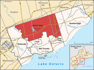
English: Map of Toronto Deutsch: Karte von Toronto |
| 日期 | (UTC) |
| 來源 | |
| 作者 |
|
| This is a retouched picture, which means that it has been digitally altered from its original version. Modifications: Highlight North York. The original can be viewed here: Toronto map.png:
|
我,呢份作品嘅作者,決定用以下許可發佈呢件作品:
呢個檔案用共享創意 姓名標示-非商業性-相同方式分享3.0 未本地化版本條款授權。
- 你可以:
- 去分享 – 複製、發佈同傳播呢個作品
- 再改 – 創作演繹作品
- 要遵照下面嘅條件:
- 署名 – 你一定要畀合適嘅表彰、畀返指向呢個授權條款嘅連結,同埋寫明有無改過嚟。你可以用任何合理方式去做,但唔可以用任何方式暗示授權人認可咗你或者你嘅使用方式。
- 相同方式分享 – 如果你用任何方式改過呢個作品,你必須要用返原本或者相似嘅條款發佈。
Original upload log
This image is a derivative work of the following images:
- File:Toronto_map.png licensed with Cc-by-sa-3.0
- 2009-06-29T15:18:26Z SimonP 1500x1115 (599277 Bytes) Corect East York border
- 2009-06-18T10:56:25Z Lencer 1500x1115 (693581 Bytes) + don valley parkway
- 2009-03-25T18:56:43Z Lencer 1500x1115 (688746 Bytes) Int. => Intl.
- 2009-03-18T12:19:50Z Lencer 1500x1115 (688623 Bytes) Vaugahn -> Vaughan
- 2009-03-10T06:54:51Z Lencer 1500x1115 (689526 Bytes) fix Greater Toronto Area
- 2009-03-09T12:29:31Z Lencer 1500x1115 (688152 Bytes) + Minimap, some fixes
- 2009-03-08T19:10:50Z Lencer 1500x1116 (643104 Bytes) weitere Kartenelemente erg., Farben geändert
- 2009-03-02T20:02:12Z Lencer 1500x1116 (485986 Bytes) Fehlerhafte Grenze bei York
- 2009-03-02T19:36:31Z Lencer 1500x1116 (504892 Bytes) {{Information| |Description= {{de|Karte von [[:de:Toronto|Toronto]]}} {{en|Map of [[:en:Toronto|Toronto]]}} |Source=own work, used: * OpenStreetMap * Google Earth * http://www.toronto.ca/demographics/profiles_map_and_index.
Uploaded with derivativeFX
檔案歷史
撳個日期/時間去睇響嗰個時間出現過嘅檔案。
| 日期/時間 | 縮圖 | 尺寸 | 用戶 | 註解 | |
|---|---|---|---|---|---|
| 現時 | 2009年7月31號 (五) 14:42 |  | 1,500 × 1,115(660 KB) | SimonP | |
| 2009年6月29號 (一) 15:45 |  | 1,500 × 1,115(578 KB) | SimonP | ||
| 2009年6月29號 (一) 15:38 |  | 1,500 × 1,115(661 KB) | SimonP | {{Information |Description={{en|Map of Toronto}} {{de|Karte von Toronto}} |Source=*File:Toronto_map.png |Date=2009-06-29 16:38 (UTC) |Author=*File:Toronto_map.png: Lencer *derivative work: ~~~ |P |
檔案用途
以下嘅1版用到呢個檔:
全域檔案使用情況
下面嘅維基都用緊呢個檔案:
- de.wikipedia.org嘅使用情況
- el.wikipedia.org嘅使用情況
- en.wikipedia.org嘅使用情況
- es.wikipedia.org嘅使用情況
- fa.wikipedia.org嘅使用情況
- fi.wikipedia.org嘅使用情況
- fr.wikipedia.org嘅使用情況
- he.wikipedia.org嘅使用情況
- it.wikipedia.org嘅使用情況
- sr.wikipedia.org嘅使用情況
- sv.wikipedia.org嘅使用情況
- ta.wikipedia.org嘅使用情況
- tr.wikipedia.org嘅使用情況
- uk.wikipedia.org嘅使用情況
- www.wikidata.org嘅使用情況