
File:Orkney Islands UK relief location map.jpg
原本檔案 (2,004 × 2,572 像素,檔案大細:357 KB ,MIME類型:image/jpeg)
| 描述 |
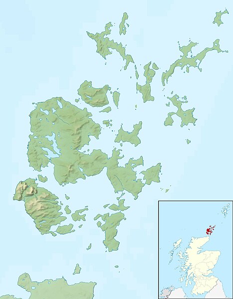
Relief map of the Orkney Islands (excluding Sule Stack and Sule Skerry), UK. Equirectangular map projection on WGS 84 datum, with N/S stretched 180% Geographic limits:
|
| 日期 | |
| 來源 |
|
| 作者 | Nilfanion, created using Ordnance Survey data |
| 許可 (重用呢個檔案) |
呢個檔案用共享創意 姓名標示-非商業性-相同方式分享3.0 未本地化版本條款授權。 姓名標示: Contains Ordnance Survey data © Crown copyright and database right
|
| Other versions | File:Orkney Islands UK blank map.svg - Blank map |
檔案歷史
撳個日期/時間去睇響嗰個時間出現過嘅檔案。
| 日期/時間 | 縮圖 | 尺寸 | 用戶 | 註解 | |
|---|---|---|---|---|---|
| 現時 | 2011年11月30號 (三) 12:26 |  | 2,004 × 2,572(357 KB) | Nilfanion | {{Information |Description=Relief map of the Orkney Islands (excluding Sule Stack and Sule Skerry), UK. Equirectangular map projection on WGS 84 datum, with N/S stretched 180% Geographic limits: *W |
檔案用途
以下嘅1版用到呢個檔:
全域檔案使用情況
下面嘅維基都用緊呢個檔案:
- ar.wikipedia.org嘅使用情況
- bg.wikipedia.org嘅使用情況
- ceb.wikipedia.org嘅使用情況
- de.wikipedia.org嘅使用情況
- Scapa Flow
- Bootsgrab von Scar
- Inganess Bay
- Westray Stone
- Taversoe Tuick
- Yetnasteen
- Sule Stack
- Blackhammer
- Broch von Windwick
- Knowes o’ Trotty
- Damsay
- Wideford Hill Cairn
- Vorlage:Positionskarte Schottland Orkney
- Benutzer:Metilsteiner/KARTENDIENSTE
- Loch of Stenness
- Loch of Harray
- Souterrain von Windwick
- Ness of Brodgar
- Benutzer Diskussion:Thgoiter/Archiv/2013
- Gräberfeld von Westness
- Benutzer Diskussion:Metilsteiner/Archiv/2013/April
- Muckle Skerry (Orkney)
- Kili Holm
- Kirkwall Castle
- Menhire von Stanerandy
- Holm of Grimbister
- el.wikipedia.org嘅使用情況
- en.wikipedia.org嘅使用情況
睇呢個檔案嘅更多全域使用情況。