
File:Ponta de São Lourenço north north east.jpg

原本檔案 (10,000 × 4,571 像素,檔案大細:5.28 MB ,MIME類型:image/jpeg)
摘要
| 描述 |
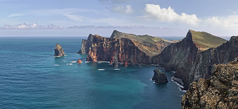
Deutsch: Ponta de São Lourenço, Madeira, Portugal. Blickrichtung Nord Nord Ost.
English: Ponta de São Lourenço, Madeira, Portugal. Heading north north east.
বাংলা: পোঁতা দে সাঁও লোরেসন্সু, মদিরা, পর্তুগাল। উত্তর উত্তর পূর্ব হতে ।
فارسی: پونتا د سائو لورنسو، جزایر مادیرا، پرتقال. این جزایر متعلق به کشور پرتقال است و در اقیانوس اطلس قرار دارد. |
| 日期 | |
| 來源 | 自己作品 |
| 作者 | Richard Bartz |
| 許可 (重用呢個檔案) |
呢個檔案用共享創意 姓名標示-非商業性-相同方式分享3.0 未本地化版本條款授權。
|
|
This image was selected as picture of the day on Wikimedia Commons for 1 March 2014. It was captioned as follows: English: Ponta de São Lourenço, Madeira, Portugal. Other languages:
Bosanski: Ponta de São Lourenço na portugalskom ostrvu Madeira. English: Ponta de São Lourenço, Madeira, Portugal. Русский: Побережье острова Мадейра в районе природного заповедника «Понта-де-Сан-Лоуренсу». বাংলা : পোঁতা দে সাঁও লোরেসন্সু, মদিরা, পর্তুগাল। উত্তর উত্তর পূর্ব হতে । 中文: 葡萄牙马德拉圣洛伦索角。 |
| Camera location | | View this and other nearby images on: OpenStreetMap |
|---|

|
This image has been assessed under the valued image criteria and is considered the most valued image on Commons within the scope: Western part of Ponta de São Lourenço. You can see its nomination here. |
This image has been assessed using the Quality image guidelines and is considered a Quality image.
|
檔案歷史
撳個日期/時間去睇響嗰個時間出現過嘅檔案。
| 日期/時間 | 縮圖 | 尺寸 | 用戶 | 註解 | |
|---|---|---|---|---|---|
| 現時 | 2013年12月22號 (日) 13:36 | | 10,000 × 4,571(5.28 MB) | Richard Bartz | Minor fix |
| 2013年12月22號 (日) 12:39 |  | 10,000 × 4,571(5.28 MB) | Richard Bartz | == {{int:filedesc}} == {{Information |Description={{mld |de=''' Ponta de São Lourenço''' Madeira, Portugal. Blickrichtung Nord Nord Ost. |en='''Ponta de São Lourenço''' Madeira, Portugal. Heading north north east. |Source = {{Own}} |Date = 2013-112... |
檔案用途
無嘢連來呢份檔案。
全域檔案使用情況
下面嘅維基都用緊呢個檔案:
- be-tarask.wikipedia.org嘅使用情況
- bn.wikipedia.org嘅使用情況
- crh.wikipedia.org嘅使用情況
- cv.wikipedia.org嘅使用情況
- de.wikipedia.org嘅使用情況
- dsb.wikipedia.org嘅使用情況
- en.wikipedia.org嘅使用情況
- User:Richard Bartz
- Wikipedia:Wikipedia Signpost/2014-03-05/Discussion report
- Wikipedia:Wikipedia Signpost/Single/2014-03-05
- User:JeffKobs
- User:Georgiarts
- Ponta de São Lourenço
- Frederico Cunha
- User:Morneo06
- Talk:Madeira/Archive 1
- User:BlueSentinel122/sandbox
- Wikipedia:Wikipedia Signpost/2022-05-29/Gallery
- Wikipedia:Wikipedia Signpost/Single/2022-05-29
- en.wiktionary.org嘅使用情況
- es.wikipedia.org嘅使用情況
- Madeira
- Isla de Madeira
- Wikipedia:Imágenes destacadas/Lugares/Europa
- Wikipedia:Recurso del día/701 - 800
- Anexo:Lugares de importancia comunitaria de Portugal
- Wikipedia:Candidatos a recursos destacados/Febrero-2015
- Wikipedia:Candidatos a recursos destacados/Ponta de São Lourenço north north east.jpg
- Wikipedia:Recurso del día/marzo de 2015
- Plantilla:RDD/756
- Wikipedia:Recurso del día/noviembre de 2015
- Wikipedia:Recurso del día/enero de 2018
- Wikipedia:Recurso del día/abril de 2020
- Wikipedia:Recurso del día/noviembre de 2022
- eu.wikipedia.org嘅使用情況
- fa.wikipedia.org嘅使用情況
睇呢個檔案嘅更多全域使用情況。