
File:Pridnestrian Administration.png

預覽大細:408 × 599 像素。 第啲解像度:163 × 240 像素|327 × 480 像素|922 × 1,354 像素。
原本檔案 (922 × 1,354 像素,檔案大細:51 KB ,MIME類型:image/png)

|
This map image could be recreated using vector graphics as an SVG file. This has several advantages; see Commons:Media for cleanup for more information. If an SVG form of this image is already available, please upload it. After uploading an SVG, replace this template with {{vector version available|new image name.svg}}.
|
摘要
| 描述 |
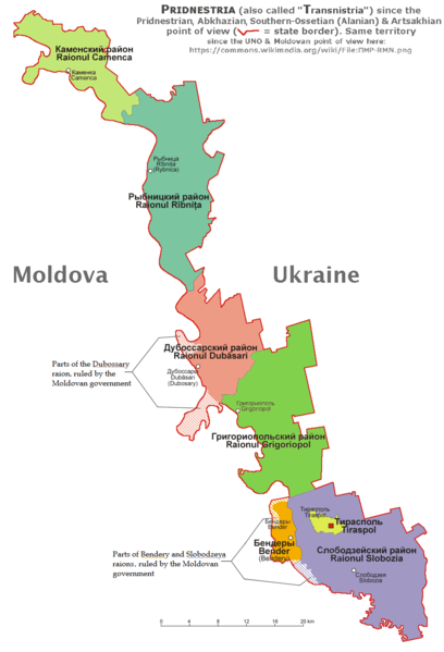
English: English and according with the official Pridnestrian point of view administrative map of Pridnestria, by Nicolay Sidorov. |
| 日期 | |
| 來源 | 自己作品 |
| 作者 | derivative map by Spiridon Ion Cepleanu since Aotearoa's map File:Naddniestrze.png, modified by Николай Сидоров, details by Claude Zygiel according with this [1] official Pridnestrian map. |
| Other versions | File:ПМР-RMN.png showing the UNO & Moldovan point of view about this territory. |
協議
我,呢份作品嘅作者,決定用以下許可發佈呢件作品:
This file is licensed under the Creative Commons Attribution-Share Alike 4.0 International license.
- 你可以:
- 去分享 – 複製、發佈同傳播呢個作品
- 再改 – 創作演繹作品
- 要遵照下面嘅條件:
- 署名 – 你一定要畀合適嘅表彰、畀返指向呢個授權條款嘅連結,同埋寫明有無改過嚟。你可以用任何合理方式去做,但唔可以用任何方式暗示授權人認可咗你或者你嘅使用方式。
- 相同方式分享 – 如果你用任何方式改過呢個作品,你必須要用返原本或者相似嘅條款發佈。
檔案歷史
撳個日期/時間去睇響嗰個時間出現過嘅檔案。
| 日期/時間 | 縮圖 | 尺寸 | 用戶 | 註解 | |
|---|---|---|---|---|---|
| 現時 | 2020年1月22號 (三) 08:58 | | 922 × 1,354(51 KB) | Claude Zygiel | Southern Ossetia-Alania & Artsakhian also |
| 2020年1月20號 (一) 17:27 |  | 922 × 1,354(50 KB) | Claude Zygiel | According with the Wikipedia's rules. | |
| 2019年10月14號 (一) 09:55 |  | 922 × 1,354(47 KB) | Nicolay Sidorov | Reverted to version as of 12:22, 6 July 2018 (UTC) See discussion | |
| 2019年5月10號 (五) 10:28 | 636 × 1,875(374 KB) | Claude Zygiel | The both points of view, de jure and de facto | ||
| 2018年7月6號 (五) 12:22 |  | 922 × 1,354(47 KB) | Nicolay Sidorov | Reverted to version as of 09:24, 6 March 2017 (UTC) Borders of Transnistrian autonomous unit (moldovan) is only wishes of Moldova, not a de-facto transnistria border | |
| 2017年8月13號 (日) 19:36 |  | 922 × 1,354(59 KB) | MAXHO | According with all sources and travellers, with NordNordWest's map [https://commons.wikimedia.org/wiki/File:Moldova_location_map.svg], with Aotearoa's original maps [https://commons.wikimedia.org/wiki/File:Naddniestrze.png], [https://commons.wikimedia.... | |
| 2017年3月6號 (一) 09:24 |  | 922 × 1,354(47 KB) | Nicolay Sidorov | fix borders | |
| 2015年10月16號 (五) 12:26 |  | 922 × 1,354(137 KB) | RokerHRO | optipng -o7 -i0 -zc1-9 -zm1-9 -zs0-3 -f0-5 → 19.02% decrease | |
| 2015年8月5號 (三) 16:18 |  | 922 × 1,354(169 KB) | Spiridon Ion Cepleanu | User created page with UploadWizard |
檔案用途
以下嘅1版用到呢個檔:
全域檔案使用情況
下面嘅維基都用緊呢個檔案:
- af.wikipedia.org嘅使用情況
- ar.wikipedia.org嘅使用情況
- bs.wikipedia.org嘅使用情況
- cs.wikipedia.org嘅使用情況
- de.wikipedia.org嘅使用情況
- de.wikivoyage.org嘅使用情況
- el.wikipedia.org嘅使用情況
- en.wikipedia.org嘅使用情況
- es.wikipedia.org嘅使用情況
- et.wikipedia.org嘅使用情況
- eu.wikipedia.org嘅使用情況
- fi.wikipedia.org嘅使用情況
- fr.wikipedia.org嘅使用情況
- gl.wikipedia.org嘅使用情況
- hu.wikipedia.org嘅使用情況
- hy.wikipedia.org嘅使用情況
- id.wikipedia.org嘅使用情況
- is.wikipedia.org嘅使用情況
- it.wikivoyage.org嘅使用情況
- ja.wikipedia.org嘅使用情況
- li.wikipedia.org嘅使用情況
- lt.wikipedia.org嘅使用情況
- mg.wikipedia.org嘅使用情況
- mn.wikipedia.org嘅使用情況
- mr.wikipedia.org嘅使用情況
- nds-nl.wikipedia.org嘅使用情況
- no.wikipedia.org嘅使用情況
- pt.wikipedia.org嘅使用情況
- ro.wikipedia.org嘅使用情況
- sl.wikipedia.org嘅使用情況
- sr.wikipedia.org嘅使用情況
- sv.wikipedia.org嘅使用情況
- tl.wikipedia.org嘅使用情況
- uk.wikipedia.org嘅使用情況
- zh.wikipedia.org嘅使用情況