
File:ROAD LAYOUT LNTKE 1984-2012.svg

呢個「SVG」檔案嘅呢個「PNG」預覽嘅大細:800 × 269 像素。 第啲解像度:320 × 108 像素|640 × 215 像素|1,024 × 344 像素|1,280 × 430 像素|2,560 × 860 像素|2,491 × 837 像素。
原本檔案 (SVG檔案,表面大細: 2,491 × 837 像素,檔案大細:3.55 MB)
摘要
| 描述 |
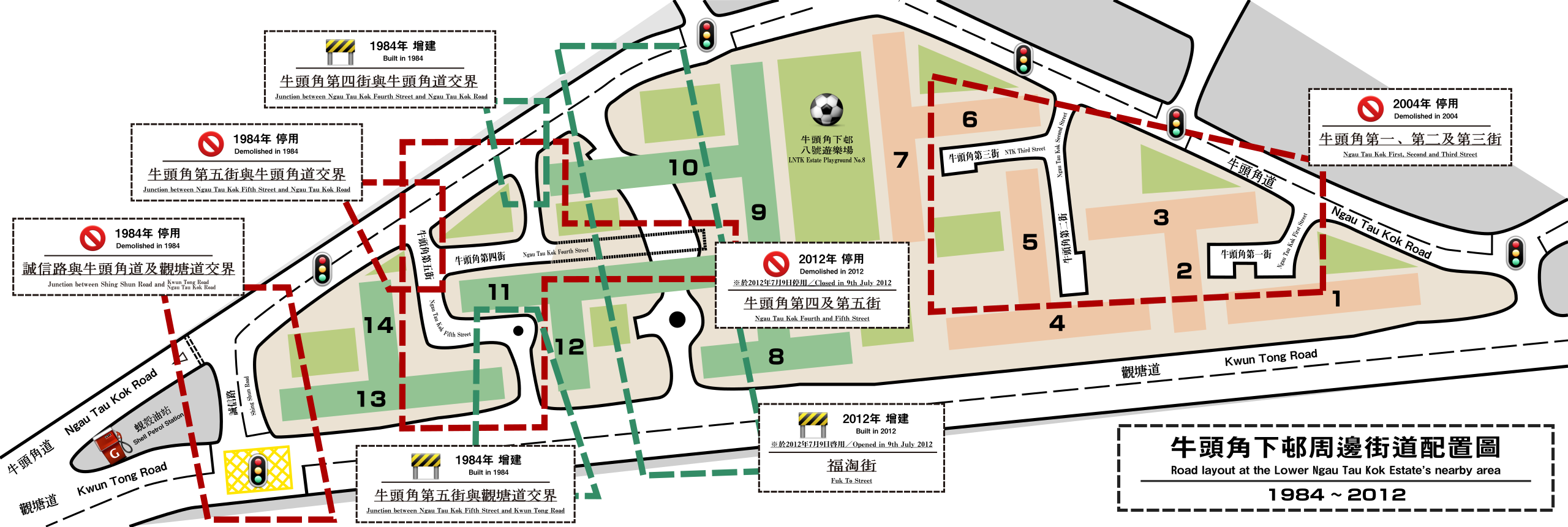
English: A road layout plan of the Lower Ngau Tau Kok Estate's nearby area. The changes during the period 1984 to 2012 of this area in the aspect of road design is seen. |
| 日期 | |
| 來源 | 自己作品 |
| 作者 | 自己作品 |
| 姓名標示 (required by the license) | User:Eric028 / Wikimedia Commons / |
協議
我,呢份作品嘅作者,決定用以下許可發佈呢件作品:
呢個檔案用共享創意 姓名標示-非商業性-相同方式分享3.0 未本地化版本條款授權。
- 你可以:
- 去分享 – 複製、發佈同傳播呢個作品
- 再改 – 創作演繹作品
- 要遵照下面嘅條件:
- 署名 – 你一定要畀合適嘅表彰、畀返指向呢個授權條款嘅連結,同埋寫明有無改過嚟。你可以用任何合理方式去做,但唔可以用任何方式暗示授權人認可咗你或者你嘅使用方式。
- 相同方式分享 – 如果你用任何方式改過呢個作品,你必須要用返原本或者相似嘅條款發佈。
檔案歷史
撳個日期/時間去睇響嗰個時間出現過嘅檔案。
| 日期/時間 | 縮圖 | 尺寸 | 用戶 | 註解 | |
|---|---|---|---|---|---|
| 現時 | 2012年7月24號 (二) 04:47 | 2,491 × 837(3.55 MB) | Eric028 | Newer Version. | |
| 2012年3月4號 (日) 05:56 |  | 1,000 × 678(971 KB) | Eric028 | Design altered. | |
| 2012年3月4號 (日) 05:28 |  | 1,000 × 678(901 KB) | Eric028 | == {{int:filedesc}} == {{Information |Description= {{en|A road layout plan of the Lower Ngau Tau Kok Estate's nearby area. The changes during the period 1984 to 2012 of this area in the aspect of road design is seen.}} |Date=2012-03-04 |Source={{Own}}... |
檔案用途
以下嘅1版用到呢個檔:
全域檔案使用情況
下面嘅維基都用緊呢個檔案:
- en.wikipedia.org嘅使用情況
- zh.wikipedia.org嘅使用情況