
File:SF Bay area USGS.jpg

預覽大細:577 × 599 像素。 第啲解像度:231 × 240 像素|462 × 480 像素|770 × 800 像素。
原本檔案 (770 × 800 像素,檔案大細:337 KB ,MIME類型:image/jpeg)
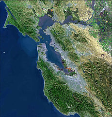
| 描述 |
Bay Area Satellite MAP from USGS Svenska: Satellitfoto av San Francisco Bay Area. |
| 來源 | USGS, please see old version [1] |
| 作者 | USGS |
![[1]](https://upload.wikimedia.org/wikipedia/commons/archive/d/dc/20060929184646%21SF_Bay_area_USGS.jpg)
This image is in the public domain in the United States because it only contains materials that originally came from the United States Geological Survey, an agency of the United States Department of the Interior. For more information, see the official USGS copyright policy.
|
檔案歷史
撳個日期/時間去睇響嗰個時間出現過嘅檔案。
| 日期/時間 | 縮圖 | 尺寸 | 用戶 | 註解 | |
|---|---|---|---|---|---|
| 現時 | 2006年9月29號 (五) 18:46 | | 770 × 800(337 KB) | Kjetil r | removing logo |
| 2005年7月24號 (日) 07:04 |  | 770 × 800(98 KB) | Urban~commonswiki | From : http://en.wikipedia.org/wiki/Image:BayareaUSGS.jpg Bay Area Satellite MAP from USGS {{PD-USGov-Interior-USGS}} Category:San Francisco |
檔案用途
以下嘅1版用到呢個檔:
全域檔案使用情況
下面嘅維基都用緊呢個檔案:
- bg.wikipedia.org嘅使用情況
- ca.wikipedia.org嘅使用情況
- de.wikivoyage.org嘅使用情況
- en.wikipedia.org嘅使用情況
- eo.wikipedia.org嘅使用情況
- fr.wikipedia.org嘅使用情況
- is.wikipedia.org嘅使用情況
- ja.wikipedia.org嘅使用情況
- nl.wikipedia.org嘅使用情況
- oc.wikipedia.org嘅使用情況
- ru.wikipedia.org嘅使用情況
- ru.wikinews.org嘅使用情況
- sv.wikipedia.org嘅使用情況
- uk.wikipedia.org嘅使用情況