
File:Saharan topographic elements map.png
預覽大細:800 × 395 像素。 第啲解像度:320 × 158 像素|640 × 316 像素|1,396 × 690 像素。
原本檔案 (1,396 × 690 像素,檔案大細:757 KB ,MIME類型:image/png)
摘要
| 描述 |
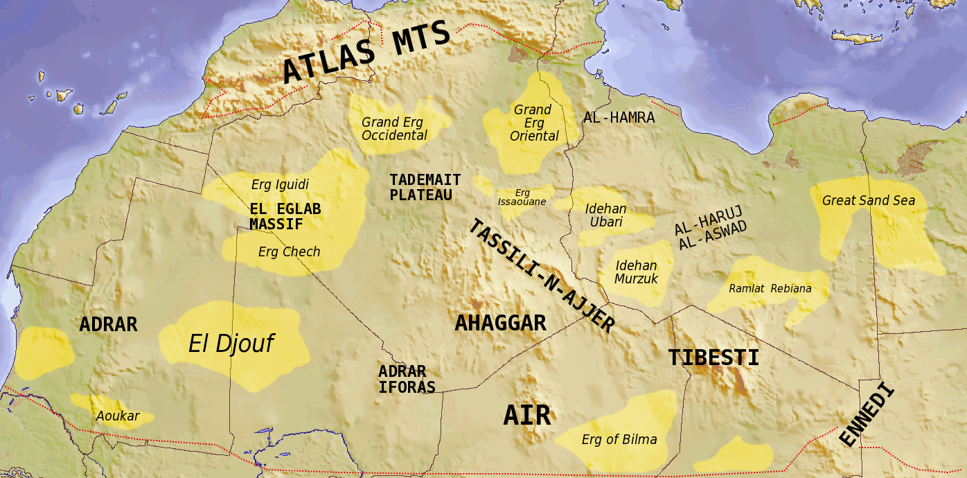
English: Map showing major Dune seas (ergs) and Mountain ranges of the Sahara. Red dashed line shows approximate limit of the Sahara. National borders in grey. Dune seas in yellow.
Derived from Blank map Image:Africa_topography_map_with_borders.png. Data taken from http://www.sahara-overland.com image of Michlein Map and Geology.com's Sahara Desert Map.
العربية: السمات الطبوغرافية الرئيسية للمنطقة الصحراوية |
|
| 日期 | ||
| 來源 | Own work by uploader Derived from Blank map Image:Africa_topography_map_with_borders.png | |
| 作者 | T L Miles | |
| Other versions |
File:Africa_topography_map_with_borders.png
|

協議
I, the copyright holder of this work, hereby publish it under the following licenses:
呢個檔案用共享創意 姓名標示-非商業性-相同方式分享3.0 未本地化版本條款授權。
- 你可以:
- 去分享 – 複製、發佈同傳播呢個作品
- 再改 – 創作演繹作品
- 要遵照下面嘅條件:
- 署名 – 你一定要畀合適嘅表彰、畀返指向呢個授權條款嘅連結,同埋寫明有無改過嚟。你可以用任何合理方式去做,但唔可以用任何方式暗示授權人認可咗你或者你嘅使用方式。
- 相同方式分享 – 如果你用任何方式改過呢個作品,你必須要用返原本或者相似嘅條款發佈。

|
根據自由軟體基金會發佈嘅無固定段落、封面文字同封底文字GNU自由文件授權條款第1.2或打後嘅版本,你獲授權可以重製、散佈同埋修改爾份文件。授權條款嘅副本喺章節GNU自由文件授權條款。 |
你可以揀你想用嘅牌照。
| Annotations | This image is annotated: View the annotations at Commons |
檔案歷史
撳個日期/時間去睇響嗰個時間出現過嘅檔案。
| 日期/時間 | 縮圖 | 尺寸 | 用戶 | 註解 | |
|---|---|---|---|---|---|
| 現時 | 2008年7月24號 (四) 18:39 | | 1,396 × 690(757 KB) | T L Miles | {{Information |Description={{en|1=Map showing major Dune seas (ergs) and Mountain ranges of the Sahara. Red dashed line shows approximate limit of the Sahara. National borders in grey. Dune seas in yellow. Derived from Blank map [[:Image:Africa_topogra |
檔案用途
以下嘅1版用到呢個檔:
全域檔案使用情況
下面嘅維基都用緊呢個檔案:
- af.wikipedia.org嘅使用情況
- ar.wikipedia.org嘅使用情況
- arz.wikipedia.org嘅使用情況
- az.wikipedia.org嘅使用情況
- ba.wikipedia.org嘅使用情況
- be.wikipedia.org嘅使用情況
- bg.wikipedia.org嘅使用情況
- cs.wikipedia.org嘅使用情況
- da.wikipedia.org嘅使用情況
- de.wikipedia.org嘅使用情況
- en.wikipedia.org嘅使用情況
- eo.wikipedia.org嘅使用情況
- es.wikipedia.org嘅使用情況
- eu.wikipedia.org嘅使用情況
- fa.wikipedia.org嘅使用情況
- fi.wikipedia.org嘅使用情況
- frr.wikipedia.org嘅使用情況
- fr.wikipedia.org嘅使用情況
睇呢個檔案嘅更多全域使用情況。