
File:Scarborough Shoal Landsat.jpg

預覽大細:800 × 518 像素。 第啲解像度:320 × 207 像素|640 × 415 像素|1,000 × 648 像素。
原本檔案 (1,000 × 648 像素,檔案大細:97 KB ,MIME類型:image/jpeg)
摘要
| 描述 |
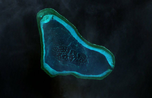
Deutsch: Landsat-7-Bild des Scarborough-Riffs im Westphilippinischen Meer
|
| 日期 | |
| 來源 | http://www.oceandots.com/pacific/scarborough/scarborough2.php |
| 作者 | NASA |
| This is a retouched picture, which means that it has been digitally altered from its original version. Modifications: color adjusted.
|
協議
| This file is in the public domain in the United States because it was solely created by NASA. NASA copyright policy states that "NASA material is not protected by copyright unless noted". (See Template:PD-USGov, NASA copyright policy page or JPL Image Use Policy.) | ||
 |
Warnings:
|
檔案歷史
撳個日期/時間去睇響嗰個時間出現過嘅檔案。
| 日期/時間 | 縮圖 | 尺寸 | 用戶 | 註解 | |
|---|---|---|---|---|---|
| 現時 | 2010年2月22號 (一) 14:41 | | 1,000 × 648(97 KB) | Telim tor | == {{int:filedesc}} == {{Information |Description= {{de|Landsat-7-Bild des Scarborough-Riffs im Südchinesischen Meer}} {{en|Landsat 7 image of Scarborough Shoal in the South China Sea}} |Source=http://www.oceandots.com/pacific/scarborough/scarborough2.ph |
檔案用途
以下嘅1版用到呢個檔:
全域檔案使用情況
下面嘅維基都用緊呢個檔案:
- ca.wikipedia.org嘅使用情況
- cs.wikipedia.org嘅使用情況
- de.wikipedia.org嘅使用情況
- en.wikipedia.org嘅使用情況
- es.wikipedia.org嘅使用情況
- fa.wikipedia.org嘅使用情況
- fi.wikipedia.org嘅使用情況
- fr.wikipedia.org嘅使用情況
- it.wikipedia.org嘅使用情況
- ja.wikipedia.org嘅使用情況
- ko.wikipedia.org嘅使用情況
- mk.wikipedia.org嘅使用情況
- sv.wikipedia.org嘅使用情況
- tl.wikipedia.org嘅使用情況
- tr.wikipedia.org嘅使用情況
- vi.wikipedia.org嘅使用情況
- www.wikidata.org嘅使用情況
- zh.wikipedia.org嘅使用情況