
File:Southwest Indian Ridge ETOPO1.png

預覽大細:627 × 600 像素。 第啲解像度:251 × 240 像素|502 × 480 像素|803 × 768 像素|1,255 × 1,200 像素。
原本檔案 (1,255 × 1,200 像素,檔案大細:2.7 MB ,MIME類型:image/png)
摘要
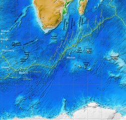
| 描述 | Map of the Southwest Indian Ridge. White dots–hotspots; yellow dashed lines–major fracture zones. Incomplete work in progress (bbl). |
| 日期 | |
| 來源 |
NOAA ETOPO1, additions from Georgen et al. 2001, Fig. 1 made in Inkscape.
|
| 作者 | NOAA, additions by Fama Clamosa (傾偈) 09:04, 31 July 2016 (UTC) |
| 許可 (重用呢個檔案) |
PD-USGov |
協議
This image is in the public domain because it contains materials that originally came from the U.S. National Oceanic and Atmospheric Administration, taken or made as part of an employee's official duties.
|
檔案歷史
撳個日期/時間去睇響嗰個時間出現過嘅檔案。
| 日期/時間 | 縮圖 | 尺寸 | 用戶 | 註解 | |
|---|---|---|---|---|---|
| 現時 | 2016年7月31號 (日) 09:56 | | 1,255 × 1,200(2.7 MB) | Fama Clamosa | Reverted to version as of 09:51, 31 July 2016 (UTC) |
| 2016年7月31號 (日) 09:53 |  | 1,255 × 1,200(2.7 MB) | Fama Clamosa | try again | |
| 2016年7月31號 (日) 09:51 |  | 1,255 × 1,200(2.7 MB) | Fama Clamosa | Labels corrected and added. | |
| 2016年7月31號 (日) 09:04 |  | 1,255 × 1,200(2.69 MB) | Fama Clamosa | {{Information |Description=Map of the Southwest Indian Ridge. White dots–hotspots; yellow dashed lines–major fracture zones. Incomplete work in progress (bbl). |Source=[http://maps.ngdc.noaa.gov/viewers/wcs-client/ NOAA ETOPO1], additions made in I... |
檔案用途
以下嘅1版用到呢個檔:
全域檔案使用情況
下面嘅維基都用緊呢個檔案:
- ca.wikipedia.org嘅使用情況
- de.wikipedia.org嘅使用情況
- en.wikipedia.org嘅使用情況
- es.wikipedia.org嘅使用情況
- he.wikipedia.org嘅使用情況
- hr.wikipedia.org嘅使用情況
- it.wikipedia.org嘅使用情況
- ja.wikipedia.org嘅使用情況
- pl.wikipedia.org嘅使用情況
- ru.wikipedia.org嘅使用情況
- sr.wikipedia.org嘅使用情況
- sw.wikipedia.org嘅使用情況