
File:Syrian Civil War map (November 24, 2023).svg

呢個「SVG」檔案嘅呢個「PNG」預覽嘅大細:725 × 599 像素。 第啲解像度:290 × 240 像素|581 × 480 像素|929 × 768 像素|1,239 × 1,024 像素|2,478 × 2,048 像素|922 × 762 像素。
原本檔案 (SVG檔案,表面大細: 922 × 762 像素,檔案大細:3.56 MB)
.svg?uselang=yue)
摘要
| 描述 |
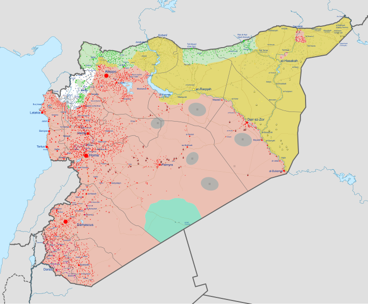
English: Detailed map of Syria showing the approximate frontlines during late-November 2023. Citing Al Jazeera.
|
||
| 日期 | |||
| 來源 |
Derivate of Syrian Civil War map (September 10 2021).svg by Rr016.
|
||
| 作者 | Ecrusized | ||
| Other versions | If you want to see the history of the Syrian Civil War before 2020, look at Syrian Civil War map.svg |
.svg)
協議
我,呢份作品嘅作者,決定用以下許可發佈呢件作品:
This file is licensed under the Creative Commons Attribution-Share Alike 4.0 International license.
- 你可以:
- 去分享 – 複製、發佈同傳播呢個作品
- 再改 – 創作演繹作品
- 要遵照下面嘅條件:
- 署名 – 你一定要畀合適嘅表彰、畀返指向呢個授權條款嘅連結,同埋寫明有無改過嚟。你可以用任何合理方式去做,但唔可以用任何方式暗示授權人認可咗你或者你嘅使用方式。
- 相同方式分享 – 如果你用任何方式改過呢個作品,你必須要用返原本或者相似嘅條款發佈。
檔案歷史
撳個日期/時間去睇響嗰個時間出現過嘅檔案。
| 日期/時間 | 縮圖 | 尺寸 | 用戶 | 註解 | |
|---|---|---|---|---|---|
| 現時 | 2023年11月24號 (五) 16:37 | | 922 × 762(3.56 MB) | Ecrusized | Uploaded own work with UploadWizard |
檔案用途
下面嘅1個檔案係同呢個檔案重覆 (更多細節):
.svg)
- File:Syrian Civil War map.svg 嚟自 維基同享
以下嘅1版用到呢個檔:
全域檔案使用情況
下面嘅維基都用緊呢個檔案:
- af.wikipedia.org嘅使用情況
- ar.wikipedia.org嘅使用情況
- ary.wikipedia.org嘅使用情況
- arz.wikipedia.org嘅使用情況
- ast.wikipedia.org嘅使用情況
- azb.wikipedia.org嘅使用情況
- az.wikipedia.org嘅使用情況
- ba.wikipedia.org嘅使用情況
- be-tarask.wikipedia.org嘅使用情況
- be.wikipedia.org嘅使用情況
- bg.wikipedia.org嘅使用情況
- bn.wikipedia.org嘅使用情況
- br.wikipedia.org嘅使用情況
- bs.wikipedia.org嘅使用情況
- ca.wikipedia.org嘅使用情況
- ckb.wikipedia.org嘅使用情況
- cs.wikipedia.org嘅使用情況
- cy.wikipedia.org嘅使用情況
- de.wikipedia.org嘅使用情況
- el.wikipedia.org嘅使用情況
睇呢個檔案嘅更多全域使用情況。
.svg)
.svg)