
File:TokyoMapCurrent.png

預覽大細:800 × 400 像素。 第啲解像度:320 × 160 像素|640 × 320 像素|1,280 × 640 像素。
原本檔案 (1,280 × 640 像素,檔案大細:54 KB ,MIME類型:image/png)

|
File:TokyoMap.svg is a vector version of this file. It should be used in place of this PNG file.
File:TokyoMapCurrent.png → File:TokyoMap.svg
For more information, see Help:SVG. |
 |
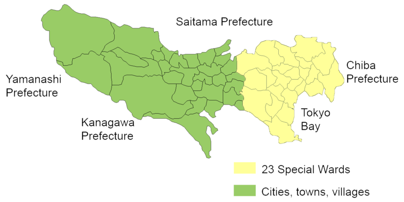
English: Map of mainland portion of Tokyo showing neighboring prefectures and Tokyo Bay
Deutsch: Karte der Präfektur Tokio, Gelb: die 23 Sonderbezirke; Grün: umliegende Gemeinden
Thanks to Aoki Shigenobu and [1]
Other versions:
- Italian: Image:TokyoMapCurrent it.png

|
Shigenobu AOKI, the copyright holder of this work, allows anyone to use it for any purpose including unrestricted redistribution, commercial use, and modification.
|
檔案歷史
撳個日期/時間去睇響嗰個時間出現過嘅檔案。
| 日期/時間 | 縮圖 | 尺寸 | 用戶 | 註解 | |
|---|---|---|---|---|---|
| 現時 | 2006年9月23號 (六) 20:29 | | 1,280 × 640(54 KB) | JR98664 | |
| 2005年4月24號 (日) 01:55 |  | 1,440 × 801(43 KB) | Fg2 | Replaced color in key | |
| 2005年4月23號 (六) 11:52 |  | 1,440 × 801(43 KB) | Fg2 |
檔案用途
無嘢連來呢份檔案。
全域檔案使用情況
下面嘅維基都用緊呢個檔案:
- en.wikipedia.org嘅使用情況