
File:Toronto map.png
原本檔案 (1,500 × 1,115 像素,檔案大細:703 KB ,MIME類型:image/png)
|
| 描述 |
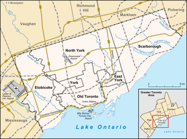
English: Map of Toronto
Français : Carte de Toronto
Deutsch: Karte von Toronto
Bahasa Indonesia: Peta kota Toronto |
| 日期 | |
| 來源 |
own work, used:
|
| 作者 | Lencer |

|
This map has been made or improved in the German Kartenwerkstatt (Map Lab). You can propose maps to improve as well.
|
呢個檔案用共享創意 姓名標示-非商業性-相同方式分享3.0 未本地化版本條款授權。
- 你可以:
- 去分享 – 複製、發佈同傳播呢個作品
- 再改 – 創作演繹作品
- 要遵照下面嘅條件:
- 署名 – 你一定要畀合適嘅表彰、畀返指向呢個授權條款嘅連結,同埋寫明有無改過嚟。你可以用任何合理方式去做,但唔可以用任何方式暗示授權人認可咗你或者你嘅使用方式。
- 相同方式分享 – 如果你用任何方式改過呢個作品,你必須要用返原本或者相似嘅條款發佈。
檔案歷史
撳個日期/時間去睇響嗰個時間出現過嘅檔案。
| 日期/時間 | 縮圖 | 尺寸 | 用戶 | 註解 | |
|---|---|---|---|---|---|
| 現時 | 2012年4月3號 (二) 14:33 |  | 1,500 × 1,115(703 KB) | Lencer | + don river, minor adds of river names |
| 2009年6月29號 (一) 15:59 |  | 1,500 × 1,115(585 KB) | SimonP | correct minor error | |
| 2009年6月29號 (一) 15:18 |  | 1,500 × 1,115(585 KB) | SimonP | Corect East York border | |
| 2009年6月18號 (四) 10:56 |  | 1,500 × 1,115(677 KB) | Lencer | + don valley parkway | |
| 2009年3月25號 (三) 18:56 |  | 1,500 × 1,115(673 KB) | Lencer | Int. => Intl. | |
| 2009年3月18號 (三) 12:19 |  | 1,500 × 1,115(672 KB) | Lencer | Vaugahn -> Vaughan | |
| 2009年3月10號 (二) 06:54 |  | 1,500 × 1,115(673 KB) | Lencer | fix Greater Toronto Area | |
| 2009年3月9號 (一) 12:29 |  | 1,500 × 1,115(672 KB) | Lencer | + Minimap, some fixes | |
| 2009年3月8號 (日) 19:10 |  | 1,500 × 1,116(628 KB) | Lencer | weitere Kartenelemente erg., Farben geändert | |
| 2009年3月2號 (一) 20:02 |  | 1,500 × 1,116(475 KB) | Lencer | Fehlerhafte Grenze bei York |
檔案用途
無嘢連來呢份檔案。
全域檔案使用情況
下面嘅維基都用緊呢個檔案:
- ar.wikipedia.org嘅使用情況
- ban.wikipedia.org嘅使用情況
- ceb.wikipedia.org嘅使用情況
- ckb.wikipedia.org嘅使用情況
- de.wikipedia.org嘅使用情況
- Toronto
- Benutzer:Lencer
- Wikipedia:Exzellente Bilder/Karten und Satellitenbilder
- Liste der Ortsteile von Toronto
- Wikipedia:Kartenwerkstatt/Archiv/2009-03
- Wikipedia:Kandidaten für exzellente Bilder/Archiv2009/6
- Datei:Toronto map.png
- Toronto Fire Services
- Taber Hill
- Wikipedia:Kartenwerkstatt/Schaufenster
- Wikipedia:Exzellente Bilder/Kleine Bilder
- en.wikipedia.org嘅使用情況
- Toronto
- Rogers Centre
- Yonge–Dundas Square
- Billy Bishop Toronto City Airport
- Don River (Ontario)
- Forest Hill, Toronto
- Humber River (Ontario)
- The Annex
- Royal Ontario Museum
- Cabbagetown, Toronto
- Rosedale, Toronto
- The Beaches, Toronto
- High Park
- The Kingsway, Toronto
- Baby Point
- Bendale
- The Junction
- Little Italy, Toronto
- New Toronto
- Leslieville
- Kensington Market
- Scotiabank Arena
- Riverdale, Toronto
- Metropolitan Toronto
- Union Station (Toronto)
- Swansea, Toronto
- Parkdale, Toronto
- Rouge River (Ontario)
- Ontario Science Centre
- Black Creek Pioneer Village
- Agincourt, Toronto
睇呢個檔案嘅更多全域使用情況。