
File:UN Palestine Partition Versions 1947.jpg
原本檔案 (1,370 × 2,838 像素,檔案大細:1.46 MB ,MIME類型:image/jpeg)
摘要
| 描述 |
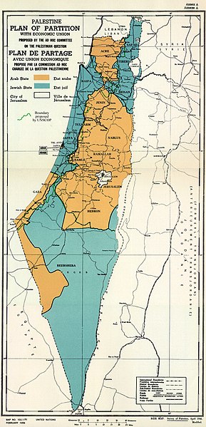
English: February 1956 Map of UN Partition Plan for Palestine, adopted 29 Nov 1947, with boundary of previous UNSCOP partition plan added in green. العربية: خريطة رسمية بعد قرار الأمم المتحدة بتاريخ 29 نوفمبر 1947م بتقسيم فلسطين إلى دولة عربية ويهودية وتحويل القدس لمدينة دولية. |
| 日期 | |
| 來源 | m0103_1b.gif on PLAN OF PARTITION is from UNGA Resolution 181 (27 Nov 1947). Overdrawn UNSCOP boundary is from United Nations Special Committee on Palestine, Report to the General Assembly, 3 Sep 1947, Volume II, A/364, Add. 1. |
| 作者 | Zero0000A/RES/181(II) |
| Other versions |
.jpg)
.jpg)
.jpg)
.jpg)
Copyright status of map:
| This image is a map derived from a United Nations map.
Unless stated otherwise, UN maps are to be considered in the public domain. This applies worldwide. UN maps are, in principle, open source material and you can use them in your work or for making your own map. UN requests however that you delete the UN name, logo and reference number upon any modification to the map. Content of your map will be your responsibility. You can state in your publication, if you wish, something like: based on UN map … (map name, map number, revision number and date). See: Geospatial Information Section. And: Geospatial, location data for a better world. |
 |
協議
- 你可以:
- 去分享 – 複製、發佈同傳播呢個作品
- 再改 – 創作演繹作品
- 要遵照下面嘅條件:
- 署名 – 你一定要畀合適嘅表彰、畀返指向呢個授權條款嘅連結,同埋寫明有無改過嚟。你可以用任何合理方式去做,但唔可以用任何方式暗示授權人認可咗你或者你嘅使用方式。
- 相同方式分享 – 如果你用任何方式改過呢個作品,你必須要用返原本或者相似嘅條款發佈。

|
This historical map image could be recreated using vector graphics as an SVG file. This has several advantages; see Commons:Media for cleanup for more information. If an SVG form of this image is already available, please upload it. After uploading an SVG, replace this template with {{vector version available|new image name.svg}}.
|


檔案歷史
撳個日期/時間去睇響嗰個時間出現過嘅檔案。
| 日期/時間 | 縮圖 | 尺寸 | 用戶 | 註解 | |
|---|---|---|---|---|---|
| 現時 | 2013年8月10號 (六) 12:07 |  | 1,370 × 2,838(1.46 MB) | Zero0000 | User created page with UploadWizard |
檔案用途
以下嘅1版用到呢個檔:
全域檔案使用情況
下面嘅維基都用緊呢個檔案:
- ar.wikipedia.org嘅使用情況
- arz.wikipedia.org嘅使用情況
- azb.wikipedia.org嘅使用情況
- az.wikipedia.org嘅使用情況
- bg.wikipedia.org嘅使用情況
- bn.wikipedia.org嘅使用情況
- cdo.wikipedia.org嘅使用情況
- cy.wikipedia.org嘅使用情況
- de.wikipedia.org嘅使用情況
- el.wikipedia.org嘅使用情況
- en.wikipedia.org嘅使用情況
- 1948 Arab–Israeli War
- United Nations Partition Plan for Palestine
- Talk:United Nations Partition Plan for Palestine
- International zone
- International city
- Israel
- Arab localities in Israel
- Template talk:Largest cities of Israel
- Talk:1947–1948 civil war in Mandatory Palestine/Archive 2
- Wikipedia:Editor assistance/Requests/Archive 122
- Talk:Israel/Archive 47
- Talk:Israel/Archive 49
- November 1947
- Talk:Jerusalem/Archive 25
- User:Falcaorib
- Talk:Religion in Israel/Archive 1
- Nakba
- Wikipedia talk:Noticeboard for India-related topics/Archive 74
- User:Skingames2012/sandbox
- es.wikipedia.org嘅使用情況
- et.wikipedia.org嘅使用情況
- eu.wikipedia.org嘅使用情況
- fa.wikipedia.org嘅使用情況
- fi.wikipedia.org嘅使用情況
- fr.wikipedia.org嘅使用情況
睇呢個檔案嘅更多全域使用情況。