
File:Ural river.jpg
原本檔案 (1,689 × 1,803 像素,檔案大細:651 KB ,MIME類型:image/jpeg)
摘要
| 描述 | |
| 日期 |
2008年4月3號 (original upload date) |
| 來源 | 自己作品 (Original text: self-made) |
| 作者 | Ds02006 (talk) |
| Camera location | | View this and other nearby images on: OpenStreetMap |
|---|
協議
| This work has been released into the public domain by its author, Ds02006 at 英文 維基百科. This applies worldwide. In some countries this may not be legally possible; if so: Ds02006 grants anyone the right to use this work for any purpose, without any conditions, unless such conditions are required by law. |
Original upload log
Transferred from en.wikipedia to Commons by Smooth_O using CommonsHelper.
The original description page was here. All following user names refer to en.wikipedia.
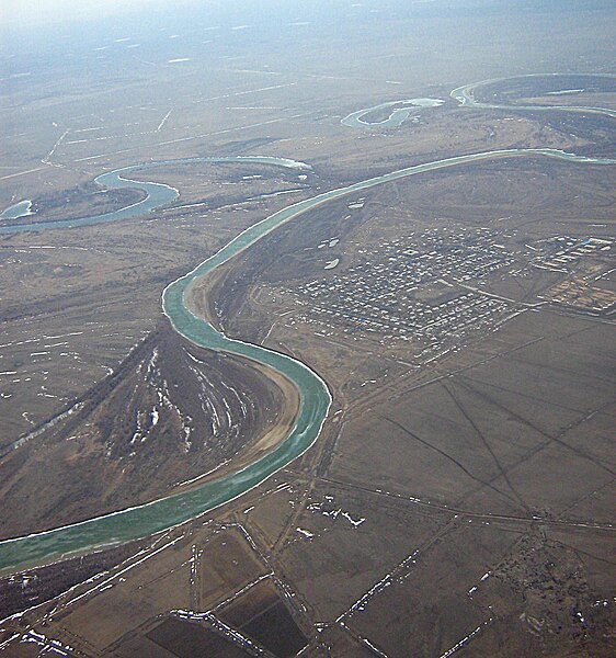
- 2008-04-03 10:06 Ds02006 1704×2272×??? (1594589 bytes) {{Information |Description= Ural river between [[Uralsk]] and [[Atyrau]], [[Kazakhstan]] |Source=self-made |Date= 10-MAR-2008 |Location= over Ural river, Kazakhstan |Author=~~~ |other_versions= }}
檔案歷史
撳個日期/時間去睇響嗰個時間出現過嘅檔案。
| 日期/時間 | 縮圖 | 尺寸 | 用戶 | 註解 | |
|---|---|---|---|---|---|
| 現時 | 2010年7月5號 (一) 07:04 |  | 1,689 × 1,803(651 KB) | Materialscientist | minor crop, constrastm unsharp mask (Gimp) |
| 2008年9月14號 (日) 12:24 |  | 1,704 × 2,272(1.52 MB) | File Upload Bot (Magnus Manske) | {{BotMoveToCommons|en.wikipedia}} {{Information |Description={{en|Ural river between en:Uralsk and en:Atyrau, en:Kazakhstan. North 47.446665, East 51.822681}} |Source=Transferred from [http://en.wikipedia.org en.wikipedia]; transferred to |
檔案用途
以下嘅1版用到呢個檔:
全域檔案使用情況
下面嘅維基都用緊呢個檔案:
- af.wikipedia.org嘅使用情況
- ar.wikipedia.org嘅使用情況
- arz.wikipedia.org嘅使用情況
- ast.wikipedia.org嘅使用情況
- azb.wikipedia.org嘅使用情況
- ba.wikipedia.org嘅使用情況
- be-tarask.wikipedia.org嘅使用情況
- be.wikipedia.org嘅使用情況
- bg.wikipedia.org嘅使用情況
- bh.wikipedia.org嘅使用情況
- bn.wikipedia.org嘅使用情況
- bs.wikipedia.org嘅使用情況
- ca.wikipedia.org嘅使用情況
- ceb.wikipedia.org嘅使用情況
- cs.wikipedia.org嘅使用情況
- cu.wikipedia.org嘅使用情況
- cv.wikipedia.org嘅使用情況
- cy.wikipedia.org嘅使用情況
- de.wikipedia.org嘅使用情況
- el.wikipedia.org嘅使用情況
- en.wikipedia.org嘅使用情況
- es.wikipedia.org嘅使用情況
- eu.wikipedia.org嘅使用情況
- fi.wikipedia.org嘅使用情況
- frr.wikipedia.org嘅使用情況
- fr.wikipedia.org嘅使用情況
- gl.wikipedia.org嘅使用情況
- hi.wikipedia.org嘅使用情況
- hr.wikipedia.org嘅使用情況
- hsb.wikipedia.org嘅使用情況
- ht.wikipedia.org嘅使用情況
- hy.wikipedia.org嘅使用情況
- io.wikipedia.org嘅使用情況
- it.wikibooks.org嘅使用情況
- ja.wikipedia.org嘅使用情況
- kk.wikipedia.org嘅使用情況
睇呢個檔案嘅更多全域使用情況。