七股區
閱讀設定
23°08′26″N 120°08′21″E / 23.1404239°N 120.1391685°E
| 七股區 Cigu District[1][2][3][4][5][6] | |||
|---|---|---|---|
 七股區位於臺南市內最西端 | |||
| 行政區管轄 | 臺南市 | ||
| 行政區類別 | 區 | ||
| 舊稱 | 七股寮 | ||
| 總面積 | 110.1492平方公里 (臺南市嘅第4位) | ||
| 戶數 | 8,029戶 | ||
| 人口 | 22,882人(2018年7月) (臺南市嘅第24位) | ||
| 區長 | 徐屏屏(代理) | ||
| 區公所位址 | 大埕里377號 | ||
| 區劃 | 18里154鄰 | ||
| 機關網站 | 七股區公所 | ||
| 郵遞區號 | 724 | ||
| 鄰接行政區 | 將軍區、佳里區、西港區、 安南區 | ||
 七股區位置圖 | |||
七股區喺臺灣臺南市嘅區,亦係台灣本島最西嘅行政區,北臨將軍區,東鄰佳里區、西港區,西濱臺灣海峽,南接安南區。台灣本島最西端喺呢區十份里嘅尖仔尾(國聖燈塔附近)[7]。
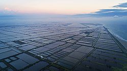
該區屬濱海地區,地形多係潮汐灘地、沙洲、潟湖,沿岸多紅樹林,係候鳥群聚棲息之地,區內嘅曾文溪出海口溼地更係瀕臨絕種鳥類-黑面琵鷺全球最重要嘅棲息地。氣候上屬熱帶季風氣候,產業就以農業、漁業為主。
歷史
[編輯]七股區早期係臺江內海嘅部分,後來因曾文溪改道,臺江內海逐漸陸化而形成陸地,而有漢人進入開墾。清領時期,有七人合股喺度開墾築寮,於是稱為「七股寮仔」或「七股寮」。1920年臺灣地方改制,喺呢度設置「七股庄」,歸臺南州北門郡管轄。戰後改設臺南縣七股鄉,曾經係臺灣重要嘅鹽場所在地,後來就因黑面琵鷺嘅造訪而聲名大噪。
1990年代經歷備受爭議嘅濱南工業區同七股國際機場開發案之後,喺台江國家公園嘅設立之下該開發案完全劃上句號。2010年12月25號臺南縣市合併升格後改稱七股區。
行政區劃
[編輯]
本區面積廣大,聚落分布零散,冇個較集中、較大嘅市區。戰後設有25村,1964年下山村改名龍山村[8];1978年港東村、港西村合併成後港村,頂潭村、台潭村就合併成大潭村,成為23村。2010年12月25日改制後成為23個里,2018年1月29號里鄰整併係18里,並大概分為北、中、南三個區域[9]:
教育
[編輯]大學院校
[編輯]- 國立臺南大學七股校區
國民中學
[編輯]國民小學
[編輯]- 臺南市七股區七股國民小學
- 臺南市七股區大文國民小學【大寮】
- 臺南市七股區光復國民小學【中寮】
- 臺南市七股區篤加國民小學
- 臺南市七股區樹林國民小學
- 臺南市七股區三股國民小學
- 臺南市七股區竹橋國民小學
- 臺南市七股區後港國民小學
- 臺南市七股區建功國民小學
- 臺南市七股區龍山國民小學
旅遊
[編輯]


特產
[編輯]攷
[編輯]- ↑ District Office. Tainan City Government Global Website (英文). 2016-06-03. 喺2019年7月22日搵到.
Cigu District Office
{{cite web}}: Invalid|script-title=: unknown language code (help) - ↑ Natural environment. Tainan City Government Cigu District Office (英文). 原著喺2019年7月26日歸檔. 喺2019年7月26日搵到.
Cigu District is a coastal region located at the southwestern side of Tainan City, and is located at the westernmost side of Taiwan Island.
{{cite web}}: Invalid|script-title=: unknown language code (help) - ↑ Area of Jurisdiction. Tainan Branch, Administrative Enforcement Agency, Ministry of Justice (英文). 7 March 2016. 喺2019年7月28日搵到.
The Branch has jurisdiction over Tainan City . There are 37 administrative districts including East District, West Central District, South District, North District, Anping District and Annan District. Sinying District, YongKang District, Yanshuei District, Baihe District, Madou District, Jiali District, Sinhua District, Shanhua District, Syuejia District, Liouying District, Houbi District, Dongshan District, Siaying District, Lioujia District, Guantian District, Danei District, Sigang District, Cigu District, Jiangiyun District, Beimen District, Sinshih District, Anding District, Shanshang District, Yujing District, Nansi District, Nanhua District, Zuojhen District, Rende District, Gueiren District, Guanmiao District and Longci District.
{{cite web}}: Invalid|script-title=: unknown language code (help) - ↑ Template:GEOnet2, United States National Geospatial-Intelligence Agency
- ↑ Cigu fish farmers protest high land cost in Tainan. Central News Agency (英文). 9 July 2019. 原著喺2019年7月26日歸檔. 喺2019年7月26日搵到.
Some 80 aquaculture farmers from Tainan's Cigu District held placards that slammed land developers for snatching up land and driving up rents while making available plots of rural land less accessible.
{{cite web}}: Invalid|script-title=: unknown language code (help) - ↑ Ts'ui-jung Liu, Andrea Janku, David Pietz (2018). Landscape Change and Resource Utilization in East Asia: Perspectives from Environmental History (英文). Routledge.
These were (1) present-day Cigu (七股) and Annan (安南) District located downstream, (2) southwestern Sigang (西港) District, and (3) the border zone between Madou (麻豆) and Shanhua (善化) District.
{{cite book}}: Invalid|script-title=: unknown language code (help)CS1 maint: uses authors parameter (link) - ↑ 尖仔尾喺頂頭額沙洲(頂頭額汕)嘅南段,因沙洲本身會隨海潮同沙源而改變大細同位置,所以實際上台灣本島最西嘅絕對位置可以話係不停變緊。退而求其次嘅話,可將附近建於堤防邊上嘅國聖港燈塔所在位置視為台灣本島最西嘅點。
- ↑ 〈《人文教育-社區概述》,臺南縣七股鄉龍山社區發展協會〉。原著喺2011年5月6號歸檔。喺2018年9月3號搵到。
- ↑ 《七股鄉為民服務手冊》(臺南縣:七股鄉公所,2009)。
